Hola weakens faster than expected, still poses a serious risk to NZ by Monday (+4 Maps)
8/03/2018 9:33pm

Tropical Cyclone Hola has weakened a little this morning dropping from a Category 4 to a Category 3 cyclone and the air pressure has risen from 952hPa last night to 962hPa this morning.
Cyclone Hola is now weakening overall and is tracking southwards towards eastern New Caledonia tonight and overnight. By tomorrow/the weekend Hola will begin tracking towards New Zealand.
We have good news and bad for New Zealand:
The good news is that the storm looks to weaken much earlier before New Zealand than both Gita and Fehi did. It also looks like it will go through the extra-tropical transition much further north than those two previous cyclones which can lessen the wind damage here too. Wind damage is still possible/likely but the intensity may be lower if it this transition occurs earlier.
The bad news it that all modelling continues to show a direct hit to northern New Zealand is looking very likely on Monday. In what shape and form is hard to lock in due to the fact the cyclone will be morphing into a new low pressure system that just 24 hours later may look unrecognisable to Hola. So there are a lot of moving parts.
Helping steer Cyclone Hola will be a large high to New Zealand’s east. If this high shrinks a little, or moves eastwards a little, it will allow Hola to take a more eastern track to New Zealand. If the high grows a bit, expands a bit, then that could push Hola further westward towards the Tasman Sea side of New Zealand and therefore more populated places. The severe weather is mostly around the centre, further afield it’s just normal cloud, wind and rain. It will take further updates across the weekend to fine tune this.
Cyclone Hola has some similarities to Cyclone Cook which hit before Easter last year in that it’s a powerful tropical cyclone but also quite compact, the severe weather and heavy rain covers a small area – so the precise tracking makes all the difference with a storm like this as to who might be impacted.
We’ll have updates across the weekend and will step them up from Sunday evening. Our next weather video will be out on Friday afternoon.
 – Current set up as of Friday AM / The Weather Company
 – Latest tracking by JTWC as of 10am Friday shows the low weakening earlier than their previous forecasts – this may still change. Northern NZ still most exposed.
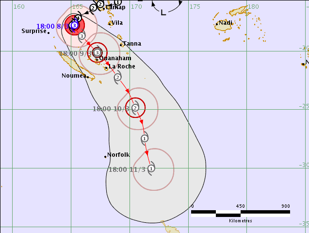 – Fiji Met Service showing Hola will have Cat 1 strength as it comes into NZ, but it will be morphing into an extra-tropical cyclone at this point and like we saw with Cyclone Gita that can rapidly see the storm change shape and intensity.
 – How Monday evening might look rainwise / The Weather Company
– WeatherWatch.co.nz
Comments
Latest Video

VIDEO: NZ RainWatch -Not much coming next 7 days
High pressure is the main feature driving NZ’s weather for the next 10 days but low pressure is trying to…
Related Articles

Weekend Newsfeed: SW flow eases, high pressure starts to grow around NZ
The cooler SW flow of this week is going to fade more going into the weekend as high pressure develops…
VIDEO: NZ RainWatch -Not much coming next 7 days
High pressure is the main feature driving NZ’s weather for the next 10 days but low pressure is trying to…

VIDEO: NZ’s Autumn showers + sub-tropical developments
NZ has a classic Autumn sou-wester today and this eases into Friday and the weekend. Next week low pressure forms…


Add new comment