
WeatherWatch.co.nz is forecasting floods for Fiji over the next 48 hours as a small but intense tropical depression passes by – or even over top. It’s possible the tropical low may reach Cyclone status for a time, although it may just hover around the Tropical Depression/Tropical Cyclone threshold.
Either way, the low is going to pack a punch rain-wise as it pulls down truly tropical air from the north into the mountainous islands of Fiji.
The tropical low is also very slow moving – in part due to the blocking high just north of New Zealand which may well protect us from the storm, but for Fiji may help slow it down and prolong the rain.
WeatherWatch.co.nz says rain may be torrential and last for a day or two. “In New Zealand we use the word ‘torrential’ to describe significant downpours which tend to last an hour or two. The torrential downpours in Fiji may last 24 to 48 hours” says head weather analyst Philip Duncan. “Flooding is absolutely a major concern”.
The Fiji Met Service is monitoring closely also, forecasting it has a high chance of reaching cyclone status in the next day or two.
The low is likely to impact areas hit by deadly Category 5 Cyclone Winston earlier this year.
Sea surface temperatures between New Zealand and around Fiji are currently two or three degrees above average – which increases the changes of tropical lows and torrential downpours and WeatherWatch.co.nz says this is also tied in with La Nina.
 Rain and wind map for Fiji this Saturday morning shows the heaviest rain approaching Nadi area / Weathermap

Areas in red indicate sea surface temperatures are currently 1 to 3 degrees above normal / Wunderground
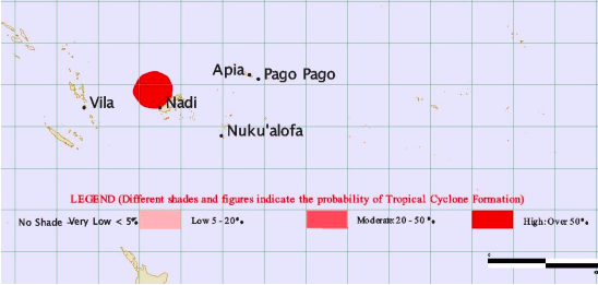 “High chance” of cyclone formation on Friday and Saturday according to Fiji Met Service
– WeatherWatch.co.nz
Comments
Latest Video

ClimateWatch: MAY’s outlook as El Niño ends, NEUTRAL pattern arrives (+Video & 13 Maps)
El Niño may be technically gone but the weather pattern it created is still with our part of the world. By…
Related Articles
ClimateWatch: MAY’s outlook as El Niño ends, NEUTRAL pattern arrives (+Video & 13 Maps)
El Niño may be technically gone but the weather pattern it created is still with our part of the world. By…

Meteors – Your Eyewitness Reports!
WeatherWatch.co.nz receives meteor reports from all over New Zealand and the globe, 24/7/365. **CASUAL COMMENTS**If you’ve seen something in the…

Weekend Newsfeed: High pressure arrives, dragging in some cloud, more settled nationwide
Sunday – High pressure crosses NZ properly and winds ease for many regions and most (but not all) showers will…


Add new comment