Cyclone Gita – Where the worst of the wind and rain will likely be (+7 Maps)
19/02/2018 2:29am

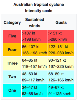
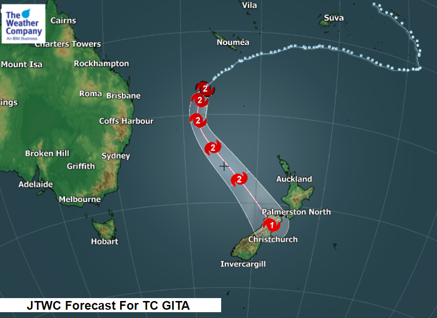
Cyclone Gita remains a ‘low end’ Category 2 Tropical Cyclone in the Tasman Sea and will reach New Zealand by Tuesday afternoon and evening, likely making landfall in the north western corner of the South Island at this stage on Tuesday night, with the equivalent of a Category 1 storm.
Cyclones can shift around a bit, sometimes by as much as 100kms, or more, from the forecast tracking but reliable computer modelling for the past 36 hours hasn’t moved much from suggesting the north west corner of the South Island is where landfall is likely – with severe weather possible for a couple of hundred kilometres in any direction from that point.
The worst of the winds (gale force and above) extend as much as 260kms from the centre so roughly the storm brings gale force winds across a 500 to 600km diameter. New Zealand is 1600kms long. The winds could also pick up further afield due to the mountains and ranges, so generally speaking a little under half of the country is exposed to gales. The low will lose its shape on Tuesday night and early Wednesday morning and that could then quickly limit the areas exposed to gales.
Rain accumulation could reach 200-300mm until Wednesday, mainly in the South Island.
At this stage it appears the upper North Island (Waikato northwards) and very lower South Island (Otago southwards) will miss the worst of this storm, but all New Zealanders should keep up to date on Gita in case anything changes. Some of these more northern or southern areas/regions may still be exposed to some severe weather as Gita morphs into a new system.
By Friday the system will be gone as a large high moves in.
WINDS/GALES:
The worst of the winds will track through central New Zealand with damaging and destructive gusts likely, especially in the Southern Alps and out towards the West Coast. The storm will be morphing into a new system overnight Tuesday/early Wednesday morning. This will lower the intensity. The hills and ranges may also protect some places from gales – making it a complicated forecast to clearly explain.
The worst of the winds will be from mid to late Tuesday afternoon and peaking into the evening at this stage. By midnight the worst may be easing – although with a secondary low forming after midnight we may see gales flaring up in other places – while easing back elsewhere.
Generally, the worst of the winds will be on Tuesday PM and perhaps very early Wednesday too.
Across Wednesday Gita’s remnants switch from a storm event to a rain event, then mostly affecting the South Island.
WIND MAPS: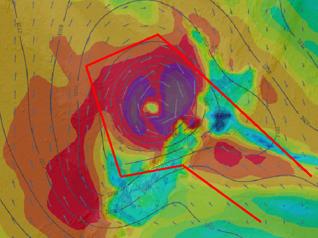
4pm Tuesday. Those inside the red lines will be dealing with the centre of the storm and gale force to severe gale force winds and gusts possibly 120 to 150km/h in the most exposed areas (the highest gusts will be in the mountains and ranges and some wind tunnels/valleys). These same mountains and ranges may also shelter some towns/communities from gales. The wind directions will also be moving around. Damaging winds may also extend outside these red lines.
As you can see in the wind map below for 7am Wednesday the storm has split into two low pressure areas and this greatly spreads out the energy, reducing and/or ending the gales but spreading gusty winds into other places. There may also be a lot of calm areas, turning Gita into a mostly ‘rain only’ event on Wednesday.

RAIN:
Rain develops ahead of the storm as early as later today, mainly in the lower half of the North Island. It’s a fairly narrow band and will be welcome by farmers in the drought zones. Tonight and overnight that narrow area of rain drifts to the very lower North Island (Wellington for example), Cook Strait and then the upper South Island into Wednesday morning. Again, this is ahead of Gita.
Across Tuesday this narrow but intense band of rain may drape over the upper South Island and Wellington and southern Wairarapa. It may cause flooding in places. Winds are a bit confusing but we expect SE winds for most, although just north of this rain band (Horowhenua northwards) there may be northerlies, ahead of Gita. The rain will be heaviest where these winds converge. (Cook Strait area – so upper South Island and very lower North Island).
By Tuesday afternoon rain will be heavy across the upper half of the South Island with localised torrential tropical downpours at night.
The heaviest rain will be from late afternoon and into the night – this is when Gita’s centre comes in and this is where the most tropical conditions are, so the rain will be very heavy and could lead to slips and flooding.
By late Tuesday evening and into Wednesday morning the bulk of the rain will be along the South Island’s eastern side, but there may still be localised heavy falls here and there on the West Coast and elswhere. Canterbury looks set to have a fair bit of rain across Wednesday which may also lead to flooding.
Rain accumulation could reach 200-300mm until Wednesday, mainly in the South Island.
RAIN ACCUMULATION MAPS:


IN A NUT SHELL:
Rain develops and increases across Tuesday. Winds ramp up Tuesday PM. Winds ease in many areas over Wednesday turning this from an upper South Island/central New Zealand storm event to a mostly South Island rain event. Keep up to date with New Zealand Government Agency MetService and their public Watches and Warnings and the public rain radar.
Remember, THINGS CAN CHANGE – this is the first of WeatherWatch.co.nz’s more detailed updates on timings of wind and rain. Gita will tomorrow transition from being a tropical cyclone to an extra-tropical cyclone. It will still be a storm during this process, however by Wednesday the new system will be much larger and less severe and will lose the storm status – being downgraded to “just a low” basically.
The forecasts are still not 100% locked in but this is the best thinking based on reliable models, meteorologists we work with daily at The Weather Company and data we trust from a variety of sources. WeatherWatch.co.nz will continue to update on Gita over the next 3 days.
– Maps by Weathermap.co.nz and The Weather Company
– WeatherWatach.co.nz
Comments
Latest Video

VIDEO: NZ RainWatch -Not much coming next 7 days
High pressure is the main feature driving NZ’s weather for the next 10 days but low pressure is trying to…
Related Articles

Weekend Newsfeed: SW flow eases, high pressure starts to grow around NZ
The cooler SW flow of this week is going to fade more going into the weekend as high pressure develops…
VIDEO: NZ RainWatch -Not much coming next 7 days
High pressure is the main feature driving NZ’s weather for the next 10 days but low pressure is trying to…

VIDEO: NZ’s Autumn showers + sub-tropical developments
NZ has a classic Autumn sou-wester today and this eases into Friday and the weekend. Next week low pressure forms…


Add new comment
JohnC on 19/02/2018 6:12am
Hi I am a regular follower of weather Watch, however like this forecast you have a wind map which shows no reference to New Zealand and therefore become an artistic blob.
Or am I missing something??
Cheers
Reply
WW Forecast Team on 19/02/2018 6:27am
Hi there, the maps are made by MetOcean NZ using GFS data and they are bit limited on inland areas – however the ‘blob’ is basically the storm so anywhere in that zone should be monitorig. We’re now partnered with IBM’s The Weather Company and we’re trialling some of their maps in recent months. Here are some extra details (this may still change).
Cheers
WW
Reply
Guest Evan on 19/02/2018 5:12am
Small bit of advice for those caught up in this storm, stay away from rooms in your home that have over hanging trees, very important, good luck.
Reply
Guest on 19/02/2018 3:55am
Gita seems to be rounding the last corner and ready to make its final run toward NZ, it’s amazing to see that it is still tropical and as of 4:45pm deep convection still persisting quite strongly in the south western quadrant with poleward outflow.
Usually when they get this far south the top of the cyclone as been well and truly ripped off and only the low level circulation remains, but Gita is still sustaining a warm core and persistent deep convection .
So there is still a lot of energy in this system, it is showing tremendous tenacity in holding on to the deep convection and warm core.
I can’t remember a cyclone like this before, so it is going to be interesting to see how far south it can get before it goes extra-tropical and whether it gains a bit of energy when it does.
Reply
WW Forecast Team on 19/02/2018 4:38am
Yes it’s quite incredible – one for the history books most likely, due to the marine heatwave keeping that warm tropical core alive for much longer than usual for so far south. Be quite interesting to look back on it all once it’s finished to see where it all precisely started to become extra-tropical.
Cheers
Philip Duncan
Reply
Paul Owen on 18/02/2018 11:59pm
Is this the 1st Cat 1 storm to make landfall on South Island?
Reply
WW Forecast Team on 19/02/2018 12:05am
Hi Paul, unsure sorry – there have been ex-cyclones to hit New Zealand including the South Island before, but there is very limited data in the public space for us to check due to the commercial set up of NIWA and MetService.
It’s certainly one of the most southern tropical cyclones in a long time (still is a tropical cyclone but will become extra-tropical at some point on Tuesday according to most forecasts).
Cheers
WW
Reply
Emma on 18/02/2018 7:42pm
What do you think the effect on the Chathams is likely to be, once Gita has passed over NZ?
Reply
WW Forecast Team on 18/02/2018 11:41pm
Ex Cyclone Gita will have weakened further, it sort of splits into two lows as it moves across the upper South Island. Rain or showers and windy conditions for the Chathams look to be on the cards, nothing extraordinary. Check out these maps here and you can see what is going on 🙂
http://www.weatherwatch.co.nz/forecast-maps/rain
Cheers
Aaron
Reply