Cyclone Cook reaches Severe Cat 3 approaching New Caledonia
9/04/2017 8:00pm

Severe Tropical Cyclone Cook is now a Category 3 storm and is approaching New Caledonia.
It’s a bad forecast for the French island nation with both flooding rains, severe storm surge and damaging winds combining tonight as the cyclone makes brief landfall.
By Tuesday evening Cook will be drifting south to south east away from New Caledonia and slowly towards New Zealand.
However Cyclone Cook is a very intense but small sized storm. The concern WeatherWatch.co.nz has at this stage is more to do with a larger sized low in the Tasman Sea joining forces with Cook to drag down more flooding tropical rains into the North Island of New Zealand.
This set up could see rain returning to flooded parts of Bay of Plenty, for example, this Wednesday then intensifying as ex-cyclone Cook passes by over Thursday and Friday with torrential rain around eastern parts of the North Island – rain heavy enough to cause even further slips and flooding as possibly more than a months worth of rain yet again falls in just a couple of days.
As for the four day Easter Weekend – it doesn’t look stormy so much as it looks unsettled for many regions. In other words a changeable forecast from day to day with a risk of some wet weather amongst the sunny and/or spells.
We’ll have more details on Cyclone Cook today in our next video update.
 Latest track map as of 8am NZT / Fiji Met
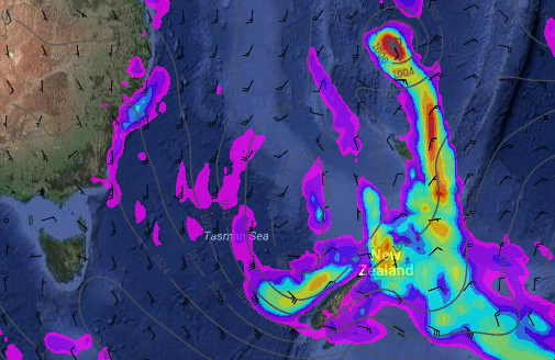 Rain map for Wednesday PM shows a large low in the Tasman Sea and a band of very heavy rain linking the North Island up with Cyclone Cook to the north / Weathermap
– WeatherWatch.co.nz
Comments
Latest Video

VIDEO: Anzac Day + weather to next Tuesday
Anzac Day looks mild for many parts of NZ with windy nor’westers gusting to gale force for some. Many regions…
Related Articles

Weekend Newsfeed: High pressure arrives, dragging in some cloud, more settled nationwide
Sunday – High pressure crosses NZ properly and winds ease for many regions and most (but not all) showers will…

Anzac Day Newsfeed: Severe gales, heavy rain for some, settled for others
Updated 4am — High pressure over northern NZ moves east of the country on Thursday while a storm south of…
VIDEO: Anzac Day + weather to next Tuesday
Anzac Day looks mild for many parts of NZ with windy nor’westers gusting to gale force for some. Many regions…


Add new comment