Confused about Cyclone Oma, or the severe weather forecast for NZ this weekend? 10 FAQ’s answered…
19/02/2019 10:13pm

> From the WeatherWatch archives
Cyclone Oma is again a Severe Category 3 tropical storm in the Coral Sea but there is now finally increasing confidence Oma will not directly hit New Zealand and will weaken in the days ahead. It’s been a long time coming but finally forecast computer models are aligning to suggest Cyclone Oma won’t directly hit New Zealand but instead may offer some help at creating an even larger low in the NZ area. To make it more confusing, news chatter about a tropical storm may now shift to talk of a cold wintry-like snap…but yes, it’s all somewhat connected.
What has changed?
For the first time in many days the various reliable forecast computer models started to align and while not in complete agreement about the future tracking of Oma they are all showing the system is less likely to directly barrel in to the country. Previously some models were in complete disagreement. The latest thinking is that the high pressure system in the Tasman Sea will push it back to the north – it may still impact Australia, or it may remain at sea.
What does this all mean for NZ?
Cyclone Oma is a big area of low pressure and is pulling down a lot of tropical energy closer to New Zealand. At the same time a high east of NZ this week and weekend will work alongside Oma to pull down more sub-tropical nor’easters. So while Oma isn’t likely to directly hit NZ, it may help fuel energy into a new system that is coming out of the Southern Ocean. We expect a large area of low pressure to form over New Zealand this weekend and it may deepen rapidly to the east, creating heavy rain and gales in some areas – but not all.
Why are we going from talking of a Tropical Cyclone to a “Wintry Blast”?
One of the few things the various forecast computer models did actually agreed on was the fact a cold southerly was coming in this Friday and weekend. If Oma doesn’t directly hit NZ then Oma doesn’t bring with it the very humid hot tropical air – instead the southerly that was forecast originally looks most likely to dominate but will form a new low that will cover most of the country on Sunday.
Is a Storm coming to NZ?
A very large area of low pressure should form this Sunday and engulf much of the county. It will be deepening quite quickly too. There is an unpredictable nature about large, rapidly deepening lows and they can create pockets of severe weather (Gales, heavy rain, big seas) but also large areas of calm and dry – some people may have a fairly pleasant weekend weatherwise despite severe weather possibly in nearby regions. We need a few more days to fine tune now.
Does Cyclone Oma bring any threat at all for NZ, or is it definitely avoiding us?
Yes there still is some threat but it’s fading more with each day. Probably a 25% risk that it could still slip north of NZ and brush northern regions. 75% of the data supports Oma remaining separate to any of the lows over NZ and being pushed away from us this weekend.
Where will severe weather most likely be this weekend?
This will still need to be locked in, but if a deep low does form just east of central NZ it could create gale easterlies on the West Coast, heavy rain on the east coast and lower North Island and may be some heavy rain in northern NZ where it has more tropical energy. Any warnings will be issued by Government forecaster MetService and they would likely be issued later this week or Saturday – but won’t be issued until forecasters can clearly lock in the size, depth and precise location of the new low being created.
Will we get soaking rains?
Again, until we know the size, depth and precise location of the new low being created this weekend it’s hard to lock in rainfall. Generally most regions should get some rain – but whether or not it’s enough to help reverse any big dry it’s harder to lock in yet. We hope to have more details in the next couple of days. We don’t expect everyone will get heavy rain.
How cold will it be?
Some parts of Southland, Otago and Canterbury this Sunday/Monday will experience daytime highs up to 20 degrees lower than where they were a recently. Highs of just 11 to 14 degrees are possible for a time. Cooler air will move in to the North Island too, but perhaps not so dramatically. However overnight lows in Auckland tomorrow night will be around 21 degrees, but by next Monday it may be 8 degrees lower.
Will Cyclone Oma hit Australia?
There is some chance Brisbane / Queensland coast may be impacted by Oma early next week if the storm does get pushed back northwards.
I’m still quite confused about everything that is happening and what that specifically means to me and things I need to do this weekend – How do I remove the clutter?
The easiest way is to use our 10 day, hourly, forecasts which are powered by IBM and the most powerful weather super computer in NZ. These hourly forecasts will give you a guide as to % of rain across the weekend each hour, so check back each day and monitor where the highest chances of rain are. These hourly forecasts are specific to your location and are updated frequently using all the world’s computer modelling, so it may be able to help you work out where the dry / calm areas will be among the rain clouds.
MODELS IN AGREEMENT:
GFS and ECMWF are the most aligned they’ve been for the weather this coming weekend. Both show Oma pushed back north, while a new larger area of low pressure deepens of the east coast of Central New Zealand. Gales and heavy rain are possible in some regions – this is yet to be locked in.
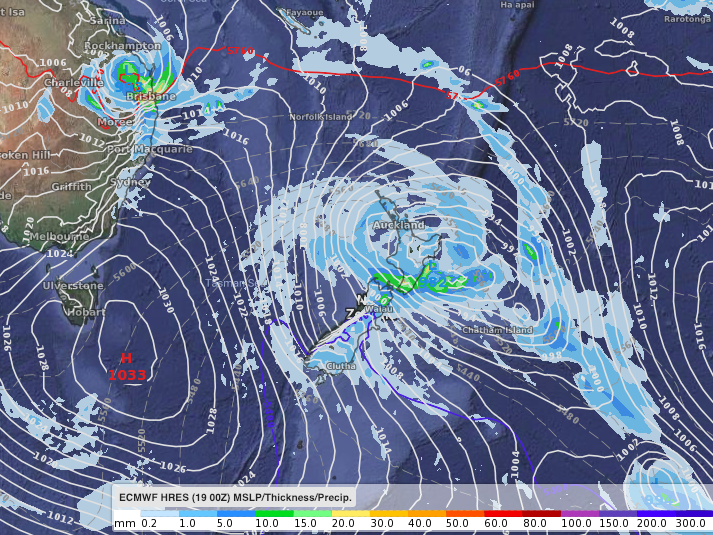
ABOVE – ECMWF for Sunday afternoon.
BELOW – GFS for Sunday afternoon.


– Tracking by JTWC (US Govt)
– WeatherWatch.co.nz
Comments
Before you add a new comment, take note this story was published on 19 Feb 2019.
Latest Video
NZ 8 day outlook as high pressure moves through
High pressure will cross the South Island this weekend bringing light winds, cold nights, frosts and fog, while the North…
Related Articles
NZ 8 day outlook as high pressure moves through
High pressure will cross the South Island this weekend bringing light winds, cold nights, frosts and fog, while the North…
Eastern cloud/showers for the NI, high pressure expands elsewhere
A colder south to south-east flow will keep clouds and showers moving into some eastern parts of the North Island…
High pressure growing slowly, eastern showers for NI
A colder airflow is spreading across all of NZ now and will continue on as high pressure slowly moves towards…


Add new comment
Yazy on 21/02/2019 6:25am
If cyclone oma doesn’t hit nz directly how are we going to have a wintry weekend and will the wintry weather continue on Monday and Tuesday???
Reply
WW Forecast Team on 21/02/2019 9:16am
Hi Yazy, take a look at our latest weather video – it explains it all. Won’t be wintry nationwide, just for some in the south.
Cheers
WW
Reply
Ed on 20/02/2019 9:00am
You weather people seem to know how to lower the mean earth temperature with 1.5 degrees but a weather forecast of a couple of days ahead seems very difficult.
Ed
Reply
WW Forecast Team on 20/02/2019 10:28am
Literally have no idea what you’re talking about.
Cheers for using our entirely free service
– WW
Reply
Guest on 20/02/2019 3:05am
A high didn’t stop bola
Reply
WW Forecast Team on 20/02/2019 10:28am
Correct, but one helped it stay stuck in place causing the major floods.
Cheers
WW
Reply
Guest on 20/02/2019 3:04am
So a mother dud even thoe we have had no rain for weeks and searing temps
Reply
Guest on 19/02/2019 10:30pm
Yea bloody fantastic forecasting WW
Reply
Guest on 19/02/2019 8:32pm
Thank you all very much for your comprehensive explanation of all the potentials.
I am most grateful.
Reply
WW Forecast Team on 19/02/2019 9:30pm
You’re very welcome, thank you for the thank you 🙂
– WW
Reply