Category 2 Cyclone UESI to move into Tasman Sea this week as another tropical storm grows (+9 Maps)
9/02/2020 10:01pm

UPDATED Monday 11:01am NZDT — A new tropical cyclone has formed north west of New Zealand and east of Queensland over the Coral Sea and has already reached Category 2 status – with another cyclone likely to form north east of New Zealand and Fiji later this week.
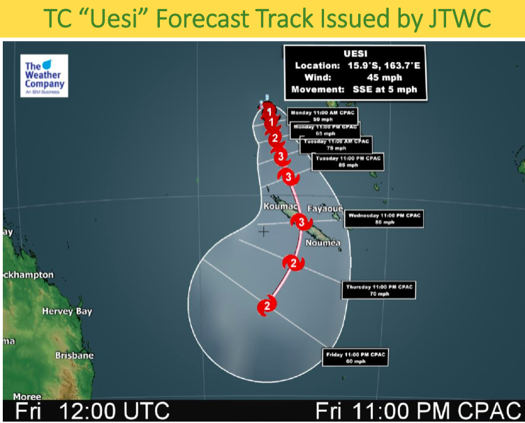
Cyclone Uesi was named by the Fiji Met Service overnight and as of 11am Monday NZDT it had grown to a Category 2 tropical storm near Vanuatu to the west. It’s far enough away from VANUATU to minimise serious impact at this stage.
Instead, it is expected to strengthen in the days ahead and may even reach Severe Category 3 status as it moves southwards near or directly over NEW CALEDONIA around Tuesday and Wednesday. The French island may be directly impacted by Uesi with damaging winds, flooding rains and dangerous seas.
On Friday Cyclone Uesi – or the remnants of the storm – will be near EASTERN AUSTRALIA and will help feed even more heavy rain into the east from BRISBANE to SYDNEY. It will also produce dangerous seas and waves. It will then grow into an extra-tropical storm which could see it intensify – hence why eastern Australia and the SOUTH ISLAND of NEW ZEALAND should be monitoring.
High pressure looks to remain in place over New Zealand this week with an easterly flow at the top of the country helping to guide this cyclone westwards towards Australia and then southwards down the Tasman Sea by the weekend.
One week from now the remnants of Uesi will likely drop away into the Southern Ocean between Tasmania and Fiordland – but there is a chance it could pull closer to NZ and bring heavy rain to the West Coast in a week from now. Modelling, unfortunately, seems to agree the North Island won’t likely be exposed to rain from this event.
ANOTHER BIGGER CYCLONE AFTER:
As the remnants of Uesi drift closer to NZ early next week a much larger tropical cyclone will likely be to our north. As early as this Friday the next storm will be forming north to north east of FIJI.
The islands of TONGA look most exposed next Monday, Feb 17th, to a possible direct hit. This second tropical cyclone may also feed very heavy rain into SAMOA.
By next Wednesday (Feb 19) this second cyclone should be well east of New Zealand, nor bringing much needed rain to the North Island due to high pressure being stuck in place over NZ still.


TRACKING THE STORMS:
TODAY – MONDAY FEB 10
FRIDAY FEB 14:
NEXT MONDAY FEB 18 – Shows the remnants of Uesi and another cyclone near Tonga…
ADDITIONAL MAPS FROM IBM:![]()


– WeatherWatch.co.nz
Comments
Latest Video

ClimateWatch: MAY’s outlook as El Niño ends, NEUTRAL pattern arrives (+Video & 13 Maps)
El Niño may be technically gone but the weather pattern it created is still with our part of the world. By…
Related Articles
ClimateWatch: MAY’s outlook as El Niño ends, NEUTRAL pattern arrives (+Video & 13 Maps)
El Niño may be technically gone but the weather pattern it created is still with our part of the world. By…

Wednesday Newsfeed: The next southerly pounces
Snow on the southern ranges, a windier south to south-west change moving into NZ, rain around the South Island and…

VIDEO: Sou’West flow dominates NZ, but easterlies might be coming later
A huge high near Tasmania is controlling NZ’s weather for the next week or two ahead – but low pressure…


Add new comment
Guest on 9/02/2020 10:54pm
Yeah they all going to aus all the time
Reply
Guest on 10/02/2020 4:31am
Good we dont need the crap,its summer
Reply
josh on 10/02/2020 7:43am
we do. its so dry so yyou like drought do you you want it to never rain and high pressure to stay forever. and cracked grounds water and food crisis do you
Reply