Wintry Wednesday & Thursday – Gales, cold, snow but some still have warm sun (+11 Maps)
23/09/2019 10:35pm

SPECIAL UPDATE: We have all the maps and infographics about the wintry blast moving in for Wednesday and Thursday nationwide. After several days of above normal temperatures many parts of the country will finally be below average by day (although some have just hit the reset back to normal after being so much warmer than normal recently).
Wednesday is the peak wind/cold day with the most polar air around the lower south eastern South Island – especially Southland and Otago but also Fiordland. On Thursday that colder air moves into the North Island and conditions gradually ease by the end of the day with a milder Friday on the way as winds swing back westerly.
More windy weather surges back in this weekend but is milder.
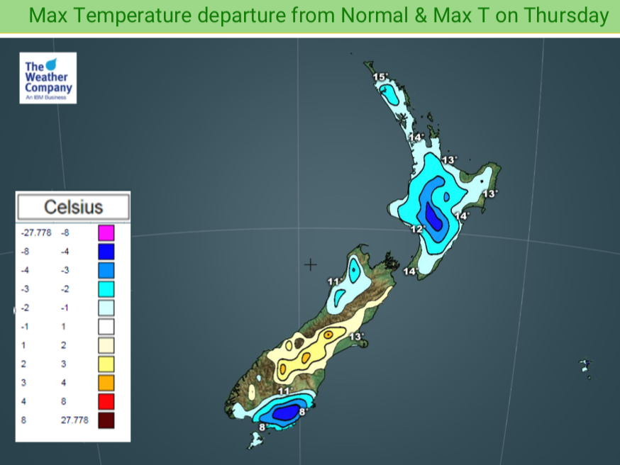
DESPITE A POLAR SOUTHERLY, PARTS OF CANTERBURY TO REMAIN WARMER THAN AVERAGE:
The coldest portion of air will be on Wednesday over Southland and Otago in particular where some low level snow flurries are likely (150 to 200m but won’t settle) and windchill for newborn stock will be tough for a time with sub-zero conditions. Remarkably, just north in Canterbury parts of the region will stay above average temperature-wise by day due to the angle of the winds. Not your normal set up with a cold southerly but shows just how much warmer than normal that region has been lately, as even with a several degree drop it’s still above average especially inland – coastal areas are cooler.
HOW LOW DOES THE SNOW GO?
Snow will fall to a few hundred metres with the odd isolated flurry going lower (like 150 or 200m) but not settling. Snow in many centres is not a main focus for WeatherWatch.co.nz forecasters but a few flurries are possible around Queenstown and maybe the Dunedin hilltops. Snow will fall nearby to Gore, Lumsden and Wanaka etc. Southland is most exposed to lower level flurries. Check your local 10 day forecast for more details to see if snow is in your forecast.
WIND:
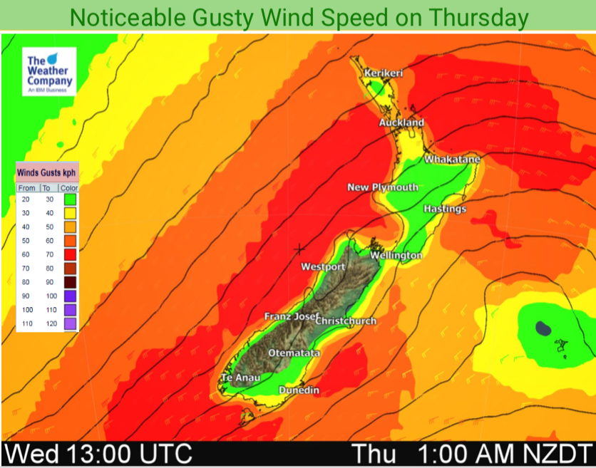
Strong winds will surge up NZ on Wednesday from the SW angle. Winds peak during Wednesday PM with gales pushing in and gusts exceeding 100km/h in exposed areas, or the usual wind tunnels. While Thursday is a blustery day with gales in some locations the peak winds do ease back as the day wears on.
Peak winds are in a 24 hour period from Noon Wednesday to Noon Thursday nationwide and may be gustiest with squally showers.
MARINE:
On top of the wind and cold the seas will be rough with dangerous waves in southern and western coastlines. People should take extreme care on the western side where waves may exceed 7 metres, including popular places like Taranaki, western Waikato and west Auckland.
SUNSHINE AND WARMTH!
Not all have bad weather – some regions, especially those facing north or north east like Nelson, Marlborough, Bay of Plenty and Northland will only have one brief cool day then the rest are sunny, dry and mild. Most days remain in the mid to late teens with mainly dry weather ahead. Check your local 10 day forecast for more details.
TEMPERATURES (+Departure from normal)

RAIN AND SNOW: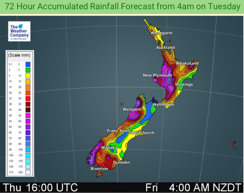

WIND:

MARINE: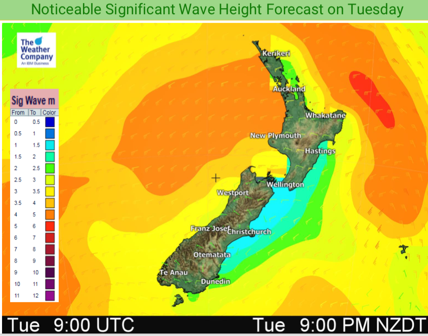


– WeatherWatch.co.nz
Comments
Latest Video

Thursday Newsfeed: Autumnal weather means highs, lows & cold fronts
A windy sou’wester kicks in for northern NZ on Thursday while a cold southerly arrives in the lower South Island…
Related Articles
Thursday Newsfeed: Autumnal weather means highs, lows & cold fronts
A windy sou’wester kicks in for northern NZ on Thursday while a cold southerly arrives in the lower South Island…

VIDEO: Cold fronts are coming – but large dry areas too
Cold fronts bringing some alpine snow and sea level rain and showers are in the forecast for parts of NZ…

Wednesday Newsfeed: Low pressure crosses NZ
A low from the Tasman Sea will cross the country on Wednesday bringing patchy rain and showers to the North…


Add new comment