Wednesday’s national forecast – Gales, rain, return to parts of South Island (+9 Maps)
1/12/2020 3:00pm

Winds ease in northern NZ today but return to the South Island and Wellington/Cook Strait area.
A storm in the Southern Ocean is the reason why gales are moving back up the South Island.
Wellington had gale southerlies yesterday. Later today gale northerlies with gusts over 80km/h are possible, maybe 100km/h tonight.
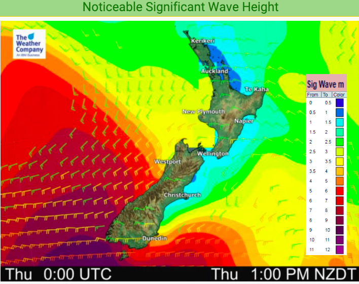
Big seas and dangerous waves will also be pushed into around the South Island across tomorrow, Thursday.
To drill down deeper don’t forget to check your HOURLY forecasts.
Here are the regional forecasts for Wednesday
Northland, Auckland, Waikato & Bay Of Plenty
A cooler start for southern inland areas, like King Country, otherwise a mix of sun and cloud under high air pressure, bringing lighter variable winds.
Highs: 19-24
Western North Island (including Central North Island)
A cooler start inland then a mix of sun and cloud with clouds increasing later. North to North west winds picking up later, especially around Cook Strait.
Highs: 17 – 21
Eastern North Island
Variable winds due to high pressure although northerlies more likely in Wairarapa while Sou’Easters fading are more likely in Gisborne and Northern Hawke’s Bay. A mix of sun and cloud.
Highs: 17-21
Wellington
Cloudy or becoming cloudy once again with strong North to NW winds developing, possibly gusting 80 to 100km/h later on.
High: 13 or 14
Marlborough & Nelson
A cool start then North to North West winds picking up today, strong by Wednesday night through Cook Strait. Clouds thickening.
Highs: 18 or 19
Canterbury
A cool start inland then a mix of sun and cloud with high cloud thickening later. Northerly quarter winds strengthening, gale nor’westers later inland near the mountains.
Highs: 14-23
West Coast
Clouds increasing with rain developing in the south with heavy falls, moving northwards into more populated places by evening. Brisk Northerlies developing.
Highs: 16 – 19
Southland & Otago
Clouds thickening and Northerlies becoming stronger with gales inland. Heavy rain in Fiordland and South Westland may spill over into western Southland and western Otago, otherwise dry.
Highs: 16-23


Comments
Latest Video

VIDEO: NZ’s Autumn showers + sub-tropical developments
NZ has a classic Autumn sou-wester today and this eases into Friday and the weekend. Next week low pressure forms…
Related Articles
VIDEO: NZ’s Autumn showers + sub-tropical developments
NZ has a classic Autumn sou-wester today and this eases into Friday and the weekend. Next week low pressure forms…

Thursday Newsfeed: A south-west flow across the country
A south-westerly flow has spread across NZ and will continue to do so for Thursday, Friday and Saturday. Windiest weather…

ClimateWatch: MAY’s outlook as El Niño ends, NEUTRAL pattern arrives (+Video & 13 Maps)
El Niño may be technically gone but the weather pattern it created is still with our part of the world. By…


Add new comment