Temps to plummet Sunday/Monday, snow risks fairly widespread but low accumulation (+7 Maps)
6/08/2021 3:29am

Gales, thunderstorms, snow, sleet, rain, windchill – oh yes, and some sunshine too. Welcome to the weather forecast for this weekend and for the start of next week.
A strong winter blast will move up New Zealand this Sunday and Monday. Ahead of it will blow mild westerlies but behind it a southerly change will hack back temperatures and bring a fairly widespread risk of snow flurries across the South Island and central North Island – although totals may not be that huge.
The positive for farmers or simply those who hate the cold is that this does look fairly short lived with temperatures bouncing back a little by next Tuesday and further by Wednesday.
SNOW:
For some places low down in the South Island it may be a rain/snow mix with a few flurries here and there. Sea level snow in NZ can be very tricky to lock in with a slight drop or rise in temperatures making all the difference between a snow event or just a wet rainy cold day with sleet.
With so many places on the margins we do expect flurries here and there, possibly to sea level. Snow is most likely above 150m but we can’t rule out some flurries to sea level – but they may not settle or accumulate.
Slightly further inland and above 150m snow may be heavy and settle. Road closures are possible in both main islands this Sunday and Monday. Snow accumulation in the mountains may reach 40cm.
In the North Island snow may fall as low as just a few hundred metres and heavy falls above 400m which will likely impact the Desert Road (SH1) and the Napier Taupo Highway (SH5).
Snow flurries may go as far north as the Waikato region and the tops of the Kaimai Ranges – but only briefly and with low accumulation. Snow will also likely fall on the summit of the Gisborne ranges.
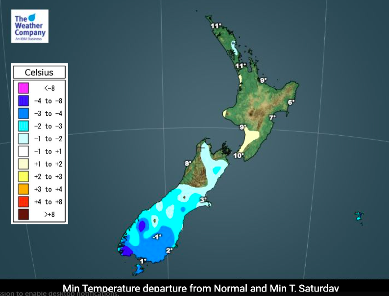
TEMPERATURES + WIND CHILL
Ahead of the cold change a fairly mild westerly will kick in. Northland, Auckland, Gisborne and Hawke’s Bay all have a chance of daytime highs in the late teens this weekend, maybe even reaching 20 degrees.
By Monday everyone in NZ has a temperature drop of a few degrees to over 10 degrees down.
Hastings has a high of +17C on Saturday and a high of +8C on Monday.
Daytime highs across Southland, Otago and Canterbury will be down to just +5 or +6C on Sunday and Monday with windchill below zero in exposed places.
Don’t forget you can check your hyper-local windchill forecasts (hour by hour for 10 full days) by visiting www.RuralWeather.co.nz.
Wind chill will be EXTREME in some higher alpine areas with -10 to -15C expected through the mountains on Monday.
At sea level wind chill will get down to around -3C in some locations and may linger for 24 to 36 hours.
For newborn lambs and calves this will be tough weather because showers/damp and strong winds will make it worse. The positive news is that milder weather should return by mid next week.


Comments
Latest Video

Weekend Newsfeed: Low pressure grows – Updated Maps
The largest low pressure zone to affect NZ so far this year will push out westwards over the Tasman Sea…
Related Articles

Monday Newsfeed: Low pressure lingers all week, maybe into next week too (+9 Maps)
A large low covering much of the Tasman Sea and NZ area will remain for most of the working week…
Weekend Newsfeed: Low pressure grows – Updated Maps
The largest low pressure zone to affect NZ so far this year will push out westwards over the Tasman Sea…

VIDEO: NZ’s weekend weather + outlook for next week
A large low will continue to affect NZ’s weather pattern across the weekend and into next week. Please check your…


Add new comment