
Several large lows are expected to directly affect New Zealand within a week starting from this weekend and potentially lasting until next weekend says WeatherWatch.co.nz. While this week is becoming windier due to high pressure being north of New Zealand and low pressure south of the country (creating a ‘squash zone’ of wind in between these systems directly over us), next week shows these lows tracking northwards and deepening and developing over New Zealand itself. This causes areas of severe weather and can make for far more changeable forecasts due to the chaos in the weather patterns at the moment.
Current forecasts are about as chaotic as we’ve seen them this year, showing a blast of westerly gales affecting those in the Roaring 40s (basically everyone south of about Whanganui). However starting this weekend and going into next week WeatherWatch.co.nz says these strong westerlies may shift further north allowing deep and large lows to form directly over, or very near, New Zealand which will disrupt our weather and may affect some travel.
This set up – coupled with a lot of solid high pressure around Australia and well to New Zealand’s north west – will mean plenty of windy weather.
Generally speaking this set up should last for the rest of May and looks to favour more rain in the west, drier weather in the east and snow on the South Island hills and ranges (possibly as low as Queenstown this weekend).
NOON TUESDAY MAY 22: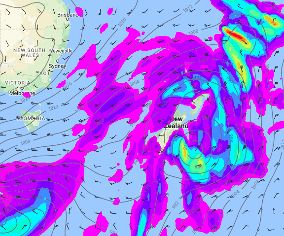
NOON FRIDAY MAY 25TH:
– WeatherWatch.co.nz
Comments
Latest Video

VIDEO: 7 Day NZ RainWatch: Who gets rain, who misses out
A cold front will bring winter-like weather into the lower South Island on Saturday but won’t make to the top…
Related Articles

Weekend Newsfeed: High pressure arrives, dragging in some cloud, more settled nationwide
Sunday – High pressure crosses NZ properly and winds ease for many regions and most (but not all) showers will…

Anzac Day Newsfeed: Severe gales, heavy rain for some, settled for others
Updated 4am — High pressure over northern NZ moves east of the country on Thursday while a storm south of…

VIDEO: Anzac Day + weather to next Tuesday
Anzac Day looks mild for many parts of NZ with windy nor’westers gusting to gale force for some. Many regions…


Add new comment