
> From the WeatherWatch archives
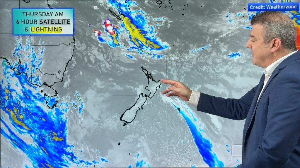
Severe thunderstorm watches were this morning issued for a number of regions across both islands and in the past hour 1569 lightning strikes have been picked up by the Lightning Tracker.
Thunderstorm Watches, which indicate severe thunderstorms are likely to develop in the coming hours, cover several regions including those affected by thunderstorms yesterday.
The regions affected by today’s watches are: Bay Of Plenty, Waikato, Waitomo, Taumarunui, Rotorua, Taupo, Taranaki, Taihape, Wanganui, Gisborne, Hawkes Bay, Buller, Canterbury High Country…
WeatherWatch.co.nz head weather analyst Philip Duncan says while this sort of weather is normal for summer the large scale isn’t. “We’re getting a taste of what the mid-west in America gets throughout their spring and summer. We don’t often see such large scale storms across such widespread portions of the country. For weather watchers this is quite extraordinary however there are definite safety concerns”.
Mr Duncan says the biggest risk with weather like this is flash flooding. “Small streams and creeks can flood within minutes and driving can be very difficult too with surface flooding and poor visibility. There’s also the risk of lightning strikes”.
Watch 1:
Issued by MetService at 10:53 am Tuesday 26 Jan 2010
Valid until 9:00 pm Tuesday 26 Jan 2010
This watch affects people in the following weather forecast districts:
Waikato, Waitomo, Taumarunui, Rotorua, Taupo, Taranaki, Taihape, Wanganui.
Conditions are favourable for widespread thunderstorm activity over many parts of the North Island again today. Some of these thunderstorms are expected to become SEVERE over central areas this afternoon and then dissipate through this evening. From Waikato to inland Taranaki to Taihape and over inland areas of Hawkes Bay, Western Gisborne and Bay of Plenty, rainfall rates could be locally torrential with hourly rates of about 40mm/hr or more.
This watch will be updated by: 02:00 pm Tuesday 26 January 2010
This watch will be updated or lifted by:10:00 pm 26 Jan 2010 NZDT
——————————————————————————–
Watch 2:
Issued by MetService at 10:53 am Tuesday 26 Jan 2010
Valid until 9:00 pm Tuesday 26 Jan 2010
This watch affects people in the following weather forecast districts:
Buller, Canterbury High Country.
Conditions are favourable for thunderstorm activity over inland parts of the upper South Island today. Some of these thunderstorms may become SEVERE over inland areas of Marlborough, Nelson, Buller and North Canterbury this afternoon and then dissipate this evening. Rainfall rates could be very heavy with intensities of 25-40mm/hr possible.
This watch will be updated by: 02:30 pm Tuesday 26 January 2010
This watch will be updated or lifted by:10:00 pm 26 Jan 2010 NZDT
——————————————————————————–
Watch 3:
Issued by MetService at 10:53 am Tuesday 26 Jan 2010
Valid until 9:00 pm Tuesday 26 Jan 2010
This watch affects people in the following weather forecast districts:
Gisborne, Hawkes Bay.
Conditions are favourable for widespread thunderstorm activity over many parts of the North Island again today. Some of these thunderstorms are expected to become SEVERE over central areas
this afternoon and then dissipate through this evening. From Waikato to inland Taranaki to Taihape and over inland areas of Hawkes Bay, Western Gisborne and Bay of Plenty, rainfall rates could be locally torrential with hourly rates of about 40mm/hr or more.
This watch will be updated by: 02:00 pm Tuesday 26 January 2010
This watch will be updated or lifted by:10:00 pm 26 Jan 2010 NZDT
——————————————————————————–
Watch 4:
Issued by MetService at 10:53 am Tuesday 26 Jan 2010
Valid until 9:00 pm Tuesday 26 Jan 2010
This watch affects people in the following weather forecast districts:
Marlborough, Nelson,.
Conditions are favourable for thunderstorm activity over inland parts of the upper South Island today.
Some of these thunderstorms may become SEVERE over inland areas of Marlborough, Nelson, Buller and North Canterbury this afternoon and then dissipate this evening. Rainfall rates could be very heavy with intensities of 25-40mm/hr possible.
This watch will be updated by: 02:30 pm Tuesday 26 January 2010
This watch will be updated or lifted by:10:00 pm 26 Jan 2010 NZDT
——————————————————————————–
Watch 5:
Issued by MetService at 10:53 am Tuesday 26 Jan 2010
Valid until 9:00 pm Tuesday 26 Jan 2010
This watch affects people in the following weather forecast districts:
Bay Of Plenty.
Conditions are favourable for widespread thunderstorm activity over many parts of the North Island again today. Some of these thunderstorms are expected to become SEVERE over central areas
this afternoon and then dissipate through this evening. From Waikato to inland Taranaki to Taihape and over inland areas of Hawkes Bay, Western Gisborne and Bay of Plenty, rainfall rates could be locally torrential with hourly rates of about 40mm/hr or more.
This watch will be updated by: 02:00 pm Tuesday 26 January 2010
This watch will be updated or lifted by:10:00 pm 26 Jan 2010 NZDT
METSERVICE SAFETY MESSAGE
Rainfall of this intensity can cause flash flooding, especially about low-lying areas such as streams, rivers or narrow valleys, and may also lead to slips. Driving conditions will also be hazardous with surface flooding and poor visibility in heavy rain. If you hear thunder and see heavy rainfall approaching, or if you feel threatened, take shelter immediately.
Watches issued by: Paul Mallinson, MetService
Comments
Before you add a new comment, take note this story was published on 26 Jan 2010.
Latest Video
High pressure for much of the country: 10 day outlook
Powerful high pressure is moving over New Zealand not only for this weekend but possibly for the next couple of…
Related Articles
NZ: Anzac Day + long weekend weather, and how next week is shaping up
High pressure is trying to move in to NZ, but there is still the chance of some heavy rain in…
Colder air for Wed/Thu + your Anzac Day & long weekend weather
Rain, showers, some snow then possible frosts are in the forecast for the next 24 hours as the low that…
Rain/Wind to ease, frosts and colder, drier, weather moving in
Low pressure will continue to drift eastwards away from the North Island over the next 24 hours, with wind and…


Add new comment
Phil Smith, LevinPhil Smith on 26/01/2010 4:30am
From 4pm weve had very large cloud buildups with a few loud thunder claps, even saw lightning coming out of the white fluffy part , we also had some thunder and rain this morning. Its all quite now though looking towards P.North its becoming a bluishgrey, could be more activity tonight fingers crossed
Reply
Derek on 26/01/2010 12:43am
Hi WW,
Looking at the satellite maps there is a low coming in from the NE, what are your predictions for it? it is looking as though Northland may get some rain even on the Anniversary Weekend. I really do not think many will mind for it is much needed.
Reply
WW Forecast Team on 26/01/2010 12:46am
Hi Derek – we’re pretty confident the low will bring cloud and wind and some rain. We’ll have full details tomorrow morning from 5am on this system.
Regards
WeatherWatch
Reply
Trish Bailey on 26/01/2010 12:29am
Rain throwing it down at the moment, very loud on the roof. There is also thunder and lightening around with a couple of the rumbles causing the house to shake a bit.
Reply
Ryan on 25/01/2010 10:56pm
There’s been a couple of claps of thunder near Rotorua in the last hour and a small shower just passing over now.
Hopefully more will eventuate this afternoon. I remember when I was in Pennsylvania, and Florida one summer the thunderstorms were insane. I had never experienced such severe storms!
Reply
Guest on 25/01/2010 11:25pm
yes there has been a bit of thunder in tokoroa for the last half an hour
Reply
Brendan Pratt on 26/01/2010 12:30am
There is none around Tauranga at the mo, there are a lot of big clouds… but not looking like rain or thunder 🙁 Is it getting worse over your way?
Keep us updated….
thanks
Reply
Brendan Pratt on 25/01/2010 10:47pm
WOW looks like there could be some big stroms around today. You where right about the thunder in Tauranga for Monday. Just light rain at about 10pm.
What about today? Could Tauranga get the windows rattled by thunder today?
Thanks
Brendan Pratt
Reply