Cyclone Gita: Latest tracking + 12 hour rainfall accumulation maps to Wednesday afternoon
19/02/2018 8:07pm

Updated 9:07am — Cyclone Gita is likely to make landfall in the upper South Island/Cook Strait area tonight, most likely between 9pm and midnight. The precise location is still unknown – despite accurate tracking maps cyclones can veer offtrack for a time which significantly shifts where severe weather may be. Keep up to date across today as the storm moves in.
Cyclone Gita remains a powerful storm this morning with Category 2 winds and may only weaken a little before landfall in New Zealand tonight:
9am Gita Update:
- It is currently category 2 strength with max (1-minute) sustained winds of 50 kts with gusts 65 kts.
- It will likely continue to have the same strength for the next 18 hours as it approaches New Zealand but should weaken slightly (by 10km/h) dropping into the Category 1 status.
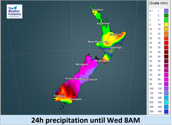
- Rain will be heavier with strong winds Tuesday, and rainfalls of 80-100mm will be possible in Wellington before Gita comes.
- The peak time of threats from Gita will be during Tuesday night.
- The worst of the rain is now in the southern half of the low pressure system – the northern half is mostly dry.
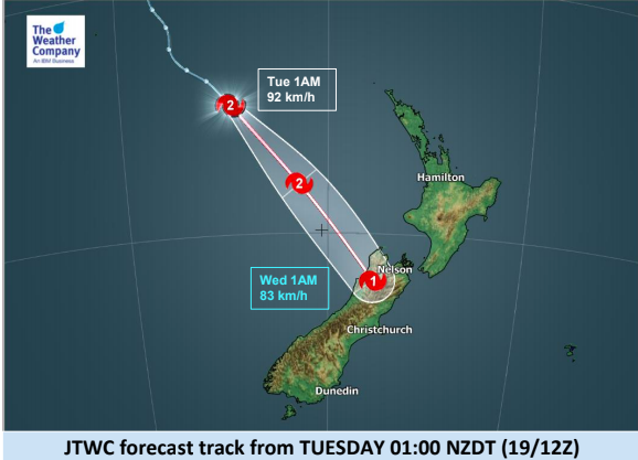
- Cyclone Gita will make landfall – at this stage (and this may still change) in the very NW corner of the South Island around 9pm-12AM NZDT. Gita may still move closer to the North Island – it remains one to watch.
- Rain accumulation will reach 200-300mm until Wednesday morning, mainly in parts of the South Island.
- Christchurch and parts of Canterbury may also get rainfall of about 100-150mm from this event which could lead to flooding. Again, where the storm makes landfall is critical to locking in the severe weather.
- There will be a high risk of flooding and slips from Tuesday night until Wednesday morning, mostly in the upper half of the South Island but possibly the lower North Island.
- There will also be threats of storm surges associated with the wind and pressure effect, mainly around Nelson.
- Gita will move into the South Pacific Ocean on Wednesday, but rain will continue in the South Island and strong winds will continue in eastern coastal areas of the South Island.


– WeatherWatch.co.nz
Comments
Latest Video

VIDEO: NZ RainWatch -Not much coming next 7 days
High pressure is the main feature driving NZ’s weather for the next 10 days but low pressure is trying to…
Related Articles

Weekend Newsfeed: SW flow eases, high pressure starts to grow around NZ
The cooler SW flow of this week is going to fade more going into the weekend as high pressure develops…
VIDEO: NZ RainWatch -Not much coming next 7 days
High pressure is the main feature driving NZ’s weather for the next 10 days but low pressure is trying to…

VIDEO: NZ’s Autumn showers + sub-tropical developments
NZ has a classic Autumn sou-wester today and this eases into Friday and the weekend. Next week low pressure forms…


Add new comment
Helen on 19/02/2018 11:27pm
Thank you for this website. I was wanting updates as my husband is in Nelson on business & all I could get (on another website) was info posted yesterday?? (hopefully updated now) but then I came across your excellent website. Thank you so much!
Reply
WW Forecast Team on 20/02/2018 12:32am
Hi there Helen, thank you very much for your feedback it’s genuinely appreciated. All the best for your husband tonight, Nelson may be quite rough for a time but hopefully it blows through quickly. We’ll be updating across tonight.
Cheers
Philip Duncan
Reply
Richard on 19/02/2018 10:10pm
It must be close to 30 years since Cyclone Bola hit?
Reply
a_animalperson on 20/02/2018 12:23am
Yeah its close, this is what the wiki says:
Cyclone Bola
1988 hurricane
Cyclone Bola was one of the costliest cyclones in the history of New Zealand, causing severe damage as an extratropical cyclone when it passed near the country in March 1988.
Indirect fatalities: 4
Date: 23 February 1988 – 4 March 1988
Direct fatalities: 3
Total fatalities: 3 direct
Damage: $82 million (1988 USD)
Affected areas: New Zealand, Fiji, Vanuatu
Reply