Australia: Rain falls in drought hit NSW, but will it make a dent? (+2 Maps)
25/08/2018 7:00pm

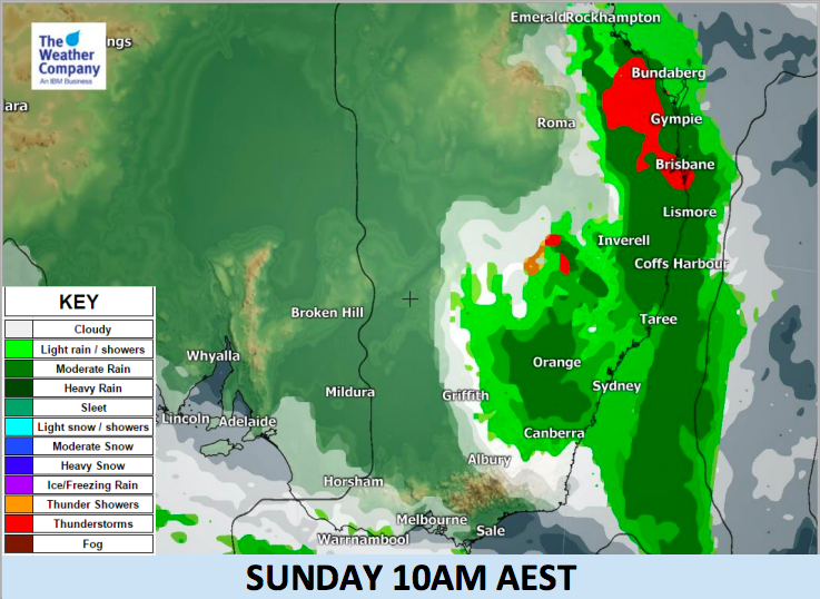
A trough over southeastern interior Australia is advancing eastwards today bringing showery rain and thunderstorms over a wide area, including drought areas in New South Wales. This wet weather will persist until this morning, then eases today as the system moves east to the coast and out over the Tasman Sea.
The set up means decent rain will be hit and miss, with only patchy lighter falls for some drought stricken areas unlikely to make much of a dent once the sun and heat returns in the days ahead.
But some will be lucky and thankful for the soaking downpours to top up tanks and troughs and bring moisture back to the soil for a time.
The main front will start moving eastward and cross the Great Dividing Range this morning and reach the coastal metropolitan area roughly from Hervey Bay, Brisbane to Taree. Localised heavy rainfall about 30 mm/h is possible where the front passes through and could lead to isolated flooding
Showery rain may occur also in Sydney on Sunday morning but heavy rainfall rates are not likely. It will mostly clear up by Sunday night as the front leaves the coast and heads towards New Zealand where it may bring some very heavy downpours to parts of the upper North Island on Wednesday or Thursday.

– WeatherWatch.co.nz
Comments
Latest Video

VIDEO: NZ RainWatch -Not much coming next 7 days
High pressure is the main feature driving NZ’s weather for the next 10 days but low pressure is trying to…
Related Articles

Weekend Newsfeed: High pressure starts to grow around NZ, easterlies in the north
The cooler SW flow of this past week is going to fade more going into the weekend as high pressure…
VIDEO: NZ RainWatch -Not much coming next 7 days
High pressure is the main feature driving NZ’s weather for the next 10 days but low pressure is trying to…

VIDEO: NZ’s Autumn showers + sub-tropical developments
NZ has a classic Autumn sou-wester today and this eases into Friday and the weekend. Next week low pressure forms…


Add new comment