Australia: Cyclone Marcus may affect Perth in a week, another cyclone may follow
16/03/2018 8:03pm

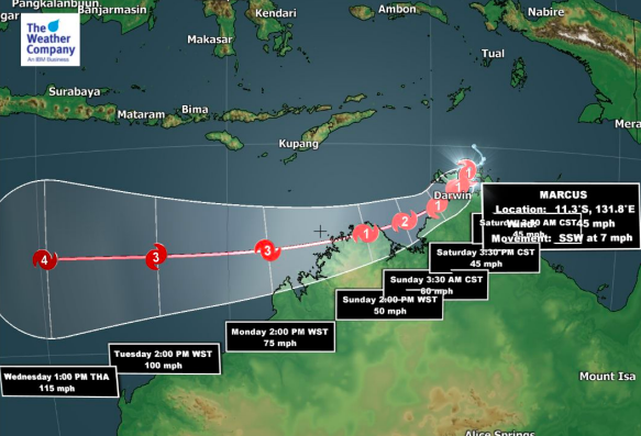
Cyclone Marcus formed Friday in northern Australia and is tracking westwards along the northern coastline and will pass Darwin today and tonight as a Category 1 tropical cyclone bringing lower end damaging winds and torrential rain.
As Marcus tracks westward over the Indian Ocean it will reach better conditions away from land to intensify and will become a major cyclone, possibly reaching Category 5 status.
Next week Marcus will eventually turn to the South Pole, pulling southwards and then southeastwards. For the past few days modelling from GFS has showed this storm hitting Perth directly, or very nearby, one week from now (Saturday March 24th). It would likely be extra-tropical by then but could still have Category 1 or 2 strength. It’s still a long way out but an interesting set up.
Not only that, but around the time Marcus will reach the south western corner of Australia another tropical cyclone will likely be forming where Marcus was born, up near Darwin.
 – March 24th shows MARCUS offshore from Perth while another tropical cyclone looks to be forming again near Darwin / Weathermap.co.nz
– WeatherWatch.co.nz
Comments
Latest Video

VIDEO: Cold changes for NZ across this week, frosts possible too
NZ has a number of colder changes coming into the country this week, as a powerful high remains south of…
Related Articles

ClimateWatch: MAY’s outlook as El Niño ends, NEUTRAL pattern arrives (+Video & 13 Maps)
El Niño may be technically gone but the weather pattern it created is still with our part of the world. By…

Weekend Newsfeed: High pressure arrives, dragging in some cloud, more settled nationwide
Sunday – High pressure crosses NZ properly and winds ease for many regions and most (but not all) showers will…

Anzac Day Newsfeed: Severe gales, heavy rain for some, settled for others
Updated 4am — High pressure over northern NZ moves east of the country on Thursday while a storm south of…


Add new comment