Animation: Big changes in air-flows moving over New Zealand
3/08/2016 9:28am

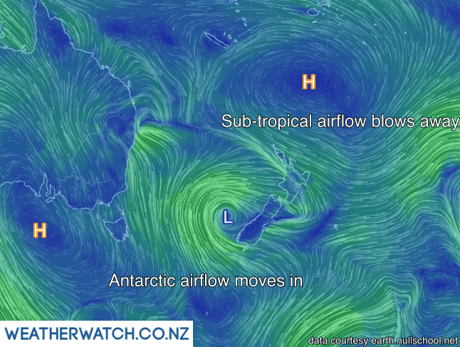
Sydney is shivering today while in New Zealand it’s been warmer than average in the upper and eastern north today and colder than average in the lower south as polar air moves in and sub-tropical air moves out for some. In fact Sydney is several degrees cooler than some North Island places this afternoon.
A deepening low in the eastern Tasman Sea off the West Coast is helping alter the polar air flow across the nation – and will do so across the weekend with the southerly injection deepening the low over the North Island on Sunday and stormy conditions possible for some.
West to north west winds continue over the North Island today – blustery at times.
Here’s how things look on Wednesday PM – and note the Antarctic southerly blowing into Sydney, where at the warmest part of the day it’s 12 degrees with a high of 13 today.
– WeatherWatch.co.nz
Comments
Latest Video

ClimateWatch: MAY’s outlook as El Niño ends, NEUTRAL pattern arrives (+Video & 13 Maps)
El Niño may be technically gone but the weather pattern it created is still with our part of the world. By…
Related Articles
ClimateWatch: MAY’s outlook as El Niño ends, NEUTRAL pattern arrives (+Video & 13 Maps)
El Niño may be technically gone but the weather pattern it created is still with our part of the world. By…

Weekend Newsfeed: High pressure starts to grow around NZ, easterlies in the north
The cooler SW flow of this past week is going to fade more going into the weekend as high pressure…

VIDEO: NZ RainWatch -Not much coming next 7 days
High pressure is the main feature driving NZ’s weather for the next 10 days but low pressure is trying to…


Add new comment