5 years ago today: Historic snow falls in Auckland & to sea level across NZ
15/08/2016 2:17am

Five years ago an Antarctic blast of historic proportions hit New Zealand. It was clear in advance this was going to be a big polar blast, but it hard to really grasp just how rare the cold snap was going to be until just a couple of days out when our data from America showed some alarming forecasts for New Zealand. It was forecasting snow to places that basically never get snow.
Weather.com/Wunderground, who had been dismissed by some in New Zealand as being too ‘overseas’ told WeatherWatch.co.nz snow was likely in Nelson, Hokitika, Wellington, Taupo – and maybe even to Auckland City. No other forecaster in New Zealand mentioned snow in these places.
At the time we wondered if perhaps the data was flawed – but we had trusted it before with snow storms in the South Island so we decided to “lock in” the forecast using some of their data. We were then the only New Zealand based forecaster to predict snow in the Auckland City forecast and once it actually happened, around lunchtime on August 15th 2011, we changed our Auckland icon to a Snow symbol. We won’t lie – that was fun to do. It also felt so incredibly strange to see a snow icon for the northern City of Sails.
The snow in Auckland was patchy – some a little further south around the Bombay Hills and Pukekohe had heavy snow that settled for a time. In the city it was broken up between graupel, snow and sleet. The city and Newmarket had fluffy snow flakes but western suburbs confirmed more graupel. The Waitakere Ranges out west also had areas of snow settle on the roads.
NIWA later confirmed the event was a once in 30+ year event – so don’t expect to see that snow icon in Auckland anytime soon!
The cold event 5 years ago locked in our confidence with data from Wunderground and is why we’ve continued to work with them to grow forecasts in NZ. During the polar snap last week many also found some of their 1500 NZ forecasts (available on our website and free app) nailed the snow and ice in some of NZ’s most remote communities.
Back in 2011 Northland’s ranges had snow to just a couple of hundred metres and snow was heavy in Taupo – and perhaps more stunningly, was heavy in Wellington City. The most spectacular snow images and videos came, in our view, from Wellington City during the 2011 event. Of course Christchurch to Dunedin to Queenstown to Invercargill had amazing snow images too, but Wellington very rarely sees such heavy snow in the city itself.
We mentioned the 5 year anniversary on social media today and loved how many of you found old photos from that historic day and shared them again.
It certainly was a memorable day for many people across New Zealand – and if history is anything to go by we may have to wait another quarter century for the next chance!
Go Back in Time 5 Years…
We’ve gone back into our storm archives and have all our coverage from that event, which you can find here:
Headlines from mid August 2011:
*Please note, due to significant digital changes in the past 5 years many of the video or photo links may no longer work/be archived.
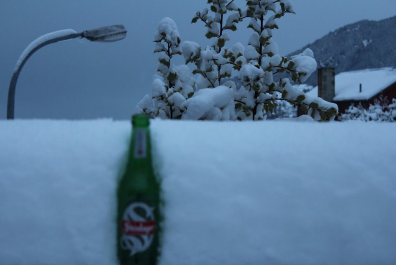
Image / Queenstown was hit by a huge amount of snow “I’ll have my beer ice cold thanks!” / Amie Saxton
– WeatherWatch.co.nz
Comments
Latest Video

ClimateWatch: MAY’s outlook as El Niño ends, NEUTRAL pattern arrives (+Video & 13 Maps)
El Niño may be technically gone but the weather pattern it created is still with our part of the world. By…
Related Articles
ClimateWatch: MAY’s outlook as El Niño ends, NEUTRAL pattern arrives (+Video & 13 Maps)
El Niño may be technically gone but the weather pattern it created is still with our part of the world. By…

Weekend Newsfeed: High pressure starts to grow around NZ, easterlies in the north
The cooler SW flow of this past week is going to fade more going into the weekend as high pressure…

VIDEO: NZ RainWatch -Not much coming next 7 days
High pressure is the main feature driving NZ’s weather for the next 10 days but low pressure is trying to…


Add new comment
Michael on 15/08/2016 2:47am
Back on this day in 2011 we cautiously brought our new born daughter home from Auckland Hospital. We were met with this unusual snow /groupel stuff when we got give which has yet to make another appearance.
Reply