
> From the WeatherWatch archives
Yesterday WeatherWatch.co.nz predicted rain, possibly heavy, for early Wednesday and this morning MetService was still predicting scattered rain for the city – yet as Aucklanders now know, today is fairly stunning. Despite a brisk sou’easter there are plenty of sunny spells and today’s high is predicted to be in the mid 20s.
So were forecasters way off the mark? Or is there a more simple explanation?
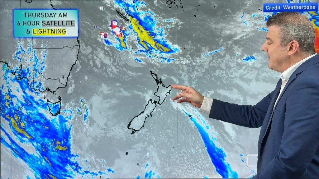
.jpg) The answer is – it was a small change that made a big difference. While we can’t comment on why MetService got it wrong today we can comment on why we did. Take a look at this map – it shows where the rain was this morning at 6am – and it was frustratingly close to Auckland. However note the wind flow – it’s a sou’easter.
The answer is – it was a small change that made a big difference. While we can’t comment on why MetService got it wrong today we can comment on why we did. Take a look at this map – it shows where the rain was this morning at 6am – and it was frustratingly close to Auckland. However note the wind flow – it’s a sou’easter.
The best way to explain a strong sou’east flow over Auckland is to call it a “reverse Canterbury nor’wester”. When a hot nor’wester blows in Canterbury chances are it’s pouring with rain and much cooler on the West Coast while Canterbury has high cloud, high temperatures and a brisk wind.
With today’s sou’east set up over the North Island we have the opposite pattern unfolding. Heavy rain – which is now causing significant slips and flooding around Gisborne – while western areas are dry, mostly sunny, and especially warm.
So how come forecasters didn’t see this coming? Well, we did – but with a secondary low developing near Northland we expected that rain band JUST off the Auckland coastline (it lay about 50kms east of Auclland over the Hauraki Gulf for much of Tuesday afternoon and overnight last night – very frustrating!) to drift a little futher west over Auckland – pushed in by more of an easterly. The slight shift to south east meant that the rain fell in Northland and the Hauraki Gulf instead. Close but no cigar.
It’s not just Auckland that benefits from a sou’easter either.
Despite slips and flooding around East Cape and Gisborne today, on the other side of the ranges it’s a different set up, with dry weather across Bay of Plenty – again, the Gisborne and Hawkes Bay ranges absorb the rain and leave a warm, brisk, and very dry sou’east wind to spread across Bay of Plenty and other north western areas. A slight shift more eastwards with the wind flow would see cooler weather, higher humidity and a higher risk of rain for Auckland and Bay of Plenty.
So basically, Gisborne and East Cape is taking the bullet for Aucklanders and other northern centres today as they shoulder the worst of the weather and protect a large populated part of the island from it. But this will only stay this way so long as the flow stays south east – and that is the prediction for the next day or two.
However the secondary low to the north of the country continues to disrupt the flow – and is producing a significant amount of cloud and rain across the top of the country.
At this stage heavy rain is continuing to fall across Gisborne, Hawkes Bay and parts of Northland as this large tropical system continues to unfold.
By head weather analyst Philip Duncan
– WeatherWatch.co.nz
Comments
Before you add a new comment, take note this story was published on 4 Apr 2012.
Latest Video
High pressure for much of the country: 10 day outlook
Powerful high pressure is moving over New Zealand not only for this weekend but possibly for the next couple of…
Related Articles
High pressure for much of the country: 10 day outlook
Powerful high pressure is moving over New Zealand not only for this weekend but possibly for the next couple of…
Foggy weather off & on next couple of weeks
High pressure in Autumn usually leads to fog and our unique fog forecaster can better help you plan ahead, especially…

Wed April 29 – No video today sorry!
Apologies but due to some tech hassles with our camera (and a fairly quiet weather forecast) we don’t have an…


Add new comment
sw on 4/04/2012 7:20am
Its the fact the high will be arriving in the tasman again with the low filling and moving south and wait…back to normal transmission from monday.
Reply