Wet, windy start to the week for northern NZ (+4 Maps)
12/10/2019 11:14pm

A low will rapidly deepen overnight tonight and across Monday as it slides in to Northland, building east to south east winds across the upper North Island with a burst of gales and also some heavy rain.
E to ESE winds will reach over 100km/h in exposed areas with isolated power cuts possible. Winds look to be strongest later on Monday PM and into Tuesday AM before easing. On Wednesday we get the windy south west change.
Rain will hug the eastern coastline of the upper North Island until Wednesday.
The centre of the low will track down Northland on Tuesday and should cross Auckland region with calmer conditions on Tuesday PM before sliding south east and exiting the North Island on Wednesday with that windy SW change.
Severe weather is likely in places so please keep up to date with tax funded MetService warnings for more information.
GUST MAP – 6PM MONDAY:
GUST MAP – NOON TUESDAY
GUST MAP – NOON WEDNESDAY: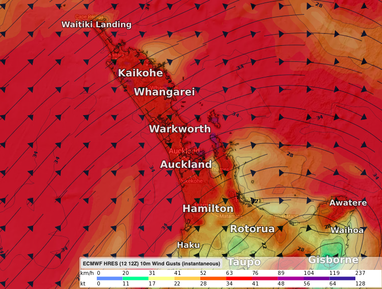
3 DAY RAINFALL UNTIL 7AM WEDNESDAY:
– WeatherWatch.co.nz
Comments
Latest Video

ClimateWatch: MAY’s outlook as El Niño ends, NEUTRAL pattern arrives (+Video & 13 Maps)
El Niño may be technically gone but the weather pattern it created is still with our part of the world. By…
Related Articles
ClimateWatch: MAY’s outlook as El Niño ends, NEUTRAL pattern arrives (+Video & 13 Maps)
El Niño may be technically gone but the weather pattern it created is still with our part of the world. By…

Weekend Newsfeed: High pressure starts to grow around NZ, easterlies in the north
The cooler SW flow of this past week is going to fade more going into the weekend as high pressure…

VIDEO: NZ RainWatch -Not much coming next 7 days
High pressure is the main feature driving NZ’s weather for the next 10 days but low pressure is trying to…


Add new comment