Warmer days ahead as huge high locks in over New Zealand (+8 Maps)
12/11/2017 11:33pm

An enormous belt of high pressure means the weather this week is more stable and overall quite good for most areas. There are a few highlights to focus on:
- Monday and Tuesday: Sunny weather with fewer cloudy areas dominates most areas in the southern part of the South Island and northwest coastline of the country.
- Temperatures in the South Island are mostly warmer than usual, except areas along northern and eastern coastlines.
- Cloudy and possibly showery weather is expected along the southeastern coastline of the North Island on Monday, because of the strong cool southerly wind. It will mostly clear up tomorrow as those winds fade out.
- Slight chances of showers also remain in Auckland, Northland and western BOP exposed to a more humid easterly wind which kicks in from tonight to tomorrow night.
- This weather set up will persist until this weekend, when a sub-tropical low once against brushes northern New Zealand.
- Highs in New Zealand often kick off with cooler weather like today (due to the southerlies) but often end on a warmer note (as the northerly flow kicks in).


 ABOVE: Maximum Temperature (T-MAX) for Monday and Tuesday shows Tuesday even warmer, especially in the north of NZ and the south, inland. Orange = Highs around the low 20s, Yellow = mid to late late teens. Green = mid teens.
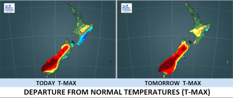
BELOW: Many places will be warmer than normal in the South Island on Tuesday especially, but the cold southerly hitting the eastern North Island means conditions there are generally cooler than usual.

– Maps by The Weather Company (an IBM business & official business partner of WeatherWatch.co.nz)
– WeatherWatch.co.nz
Comments
Latest Video

ClimateWatch: MAY’s outlook as El Niño ends, NEUTRAL pattern arrives (+Video & 13 Maps)
El Niño may be technically gone but the weather pattern it created is still with our part of the world. By…
Related Articles

Meteors – Your Eyewitness Reports!
WeatherWatch.co.nz receives meteor reports from all over New Zealand and the globe, 24/7/365. **CASUAL COMMENTS**If you’ve seen something in the…

Monday’s Newsfeed: Cold changes from the south + subtropical low in the north
High pressure south of Australia is the main driver of our weather this week but a sub-tropical low and a…
ClimateWatch: MAY’s outlook as El Niño ends, NEUTRAL pattern arrives (+Video & 13 Maps)
El Niño may be technically gone but the weather pattern it created is still with our part of the world. By…


Add new comment