
Updated 11:30pm Christmas Eve — The forecast looks mostly dry although a few isolated showers will be lurking, and some cloudy/windy areas too. While high pressure is coming in for Boxing Day it appears Christmas Day itself will still see sou’westers blowing in a few areas. The forecast is mostly dry and fairly settled – but we’ll point out the negatives below, to help you better plan your day.
Lunch/Dinner outside?
Cloudiest & Windiest regions:
Some areas will be a little windy. The highest candidates for windy weather may be Coastal Otago, Coastal Southland, Banks Peninsula, Farewell Spit area, Taranaki, some parts of Waikato, exposed parts of Auckland – these areas may also be cloudy at times as the airflow comes off the Tasman Sea but sunnier spells increasing It may also be a little windy from Tauranga up to eastern Coromandel Peninsula but with much sunnier weather expected there. The good news is we may see sunnier weather as the day goes on in many places.
Who has a risk of Showers?
There are isolated showers caught up in the sou’west flow. Most of the *isolated* and very light shower activity in the morning will be out at sea, but some will clip land to the north west. Highest risk for a light shower in the early morning looks to be along much of the western coastal side of the North Island and to the south in Southland. This won’t be much and is very isolated.
As the morning wears on the risk of a shower in the western North Island disappears – and then the cloud breaks up.
Heavier afternoon downpours may then pop up around the ranges of North Canterbury and the eastern ranges of the North Island…fading away after sunset.
Most main centres look dry in the afternoon.
Temperatures:
Definitely a bit cooler for some areas. Dunedin may only reach a high around 15 or 16 with brisk sou’westers. Christchurch the mid to late teens, Wellington late teens. The south to south west flow means Southland and other regions that face into the airflow may be quite cool for December 25th. Highs as low as 13 degrees are possible in the deep south but up to the low 20s in Central Otago. In the north, places like Auckland will be around the 20 degree mark with a breezy to brisk sou’wester but maybe low to mid 20s in eastern Northland or eastern Coromandel Peninsula. Gisborne and Napier may well be the hottest and sunniest.
Sunburn times
Yup – already EXTREME in many areas. Even in cloudy weather you can get sunburnt. Be aware of the conditions – and remember if it’s a cold day that makes zero difference to whether or not you get UV damage to your skin.
OVERALL
Generally the forecast does look fairly settled and dry, perhaps a little windy, cloudy and cooler for some regions more exposed to the south to south west flow.
Remember we now have 1500 forecasts, so you can check your favourite beach, town, rural community, city suburb or island forecast… 1500 is a lot of locations. See our homepage or download the FREE WeatherWatchNZ weather App for more!
– WeatherWatch.co.nz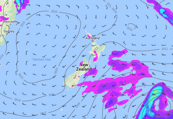 1pm Christmas Day – a few showers across NZ otherwise mostly dry. Be prepared for cloudier, cooler, weather in some of our bigger main centres though.
– WeatherWatch.co.nz
Comments
Latest Video

ClimateWatch: MAY’s outlook as El Niño ends, NEUTRAL pattern arrives (+Video & 13 Maps)
El Niño may be technically gone but the weather pattern it created is still with our part of the world. By…
Related Articles
ClimateWatch: MAY’s outlook as El Niño ends, NEUTRAL pattern arrives (+Video & 13 Maps)
El Niño may be technically gone but the weather pattern it created is still with our part of the world. By…

Wednesday Newsfeed: The next southerly pounces
Snow on the southern ranges, a windier south to south-west change moving into NZ, rain around the South Island and…

VIDEO: Sou’West flow dominates NZ, but easterlies might be coming later
A huge high near Tasmania is controlling NZ’s weather for the next week or two ahead – but low pressure…


Add new comment
Dave on 19/12/2016 12:22am
Hi boys
I am going to be in Wellington for Xmas Day so have been looking at various models including yours for a couple of weeks. I was really wanting a fine day and so it will be.
To me it will prove that your site & the models you use are the most reliable. Others have flip flopped & our own MS are really just a disgrace. Up until a day or so ago they were predicting rain & NW for the capital. That is now changed 180degrees.
I know medium range is not an exact science but at least you guys bring a human element into it which surely must prove most accurate
Cheers Dave
Reply
Tom on 19/12/2016 3:23am
You looked a bit nervous in the video, but understandable given you need to make the call! A lot of people hoping for the good sunny stuff so I hope you’re right 🙂
Thanks for all your reports over the year. I think yours are the most accurate and enjoyable.
All the best!
Tom
Reply
WW Forecast Team on 19/12/2016 3:37am
Hey Tom, yeah it’s a big call to go against the two government forecasters, but good to see they are now changing their forecasts to be more inline with ours. A fair bit of pressure this week to be accurate. We’re not locking in sunny weather for everyone, but certainly looking dry for most. Thanks for the support and kind words, very much appreciated by us.
Cheers!
Phil, Aaron and the team
Reply