
A high in the Tasman Sea directs a southwesterly airflow over New Zealand on Monday.
Overall the weather is looking to be fairly placid for Monday although there may be a little surprise or two late afternoon / evening for some.
For the upper North Island expect a mix of sun and cloud with southwesterly winds, there may be a brief shower or two also mainly early morning in the west. For the lower western North Island expect some cloud and a shower or two, winds from the west or southwest. The east coast is mainly sunny with west to southwesterly winds, during the afternoon winds tend more southerly bringing some cloud and there may be a shower or two then clearing at night.
A mostly sunny day for Wellington with breezy westerlies tending southerly around midday. Chance of an isolated shower about the Wellington region during the afternoon but more so about inland hills and ranges.
Afternoon high’s for the North Island in the high teens or early twenties about Northland through to Bay Of Plenty and along the east coast. High’s in the mid to high teens in the west from western Waikato though to Wellington.
For the West Coast of the South Island expect cloudy areas, a shower or two also especially late afternoon / evening. Winds from the southwest. Nelson has mostly sunny weather with southwesterly breezes. A mainly sunny day for Marlbrough also with afternoon easterlies, chance of an isolated shower late afternoon / evening for southern parts of the region. A mostly sunny start for Otago and Canterbury then cloud builds in the afternoon bringing the risk of an isolated shower (mainly inland). Southland sees showers, clearing in the evening, winds gusty from the west.
Afternoon high’s for the South Island generally a bit cooler then they have been recently, in the low double figures to mid teens for most. Only reaching into the high teens for the Nelson and Marlborough regions.
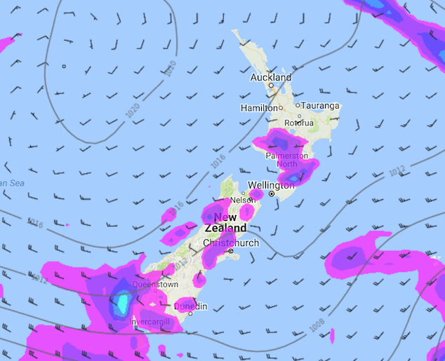
Image – Monday 6th November 2017 4pm MSLP / Rain map – weathermap.co.nz
By Weather Analyst Aaron Wilkinson – WeatherWatch.co.nz
Comments
Latest Video

Wednesday Newsfeed: New southern cold front as sub-tropical low tracks near north
A southern cold front moves into the South Island today & tonight while low pressure in the sub-tropics deepens north…
Related Articles

VIDEO: !Frost Alert as high pressure brings colder air, a change possible next week
Massive high pressure near Tasmania is bringing in a colder southerly for NZ today and that means frosts over the…
Wednesday Newsfeed: New southern cold front as sub-tropical low tracks near north
A southern cold front moves into the South Island today & tonight while low pressure in the sub-tropics deepens north…

VIDEO: Frosts, colder nights, showers & high pressure
High pressure is to the south-west of NZ, low pressure to the north-east – this creates a colder southerly quarter…


Add new comment