Spring to end & summer to kick off on a stormy note in Australia. Will it reach NZ?
28/11/2017 6:43am

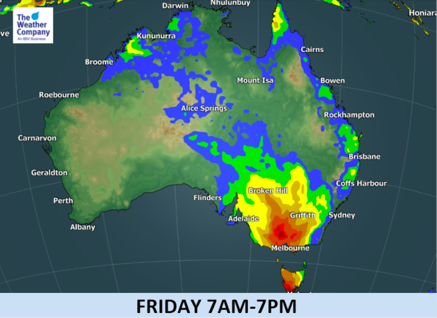
+4 Maps — Australia has a blast of weather coming this Thursday and Friday that will create gales, widespread heavy rain and severe thunderstorms across southern and eastern states.
Spring will end on a hot note. Incredibly, Hobart in Tasmania has a forecast high of 33 degrees this Thursday, the last day of spring on the meteorological calendar. By Saturday, the second day of summer, their high is just 16 with showers.
The next few days ahead see highs in the mid 30s across Melbourne, before thunderstorms with wind and heavy rain sweep through on Friday and kick the weekend off with highs in the teens.
While less dramatic, the system will encourage more rain and showers along the already drenched eastern seaboard and a few thunderstorms are possible in Sydney on Saturday.
For New Zealanders hopeful rain will reach us as the nation rapidly dries out the latest data suggests this front will become very complicated next week over the Tasman Sea – and isn’t rushing towards us.
“The front will become stuck over the Tasman Sea between two large highs next week” says WeatherWatch.co.nz head forecaster Philip Duncan. “This front over the Tasman may also tap into the sub-tropics through next week. it’s too far out to see how it might impact New Zealand but it’s probably safe to say while this front rushes into Australia this Friday it may take an entire week, or longer, to reach our shores due to so much high pressure in the way. What shape it is by then is the question we can’t yet answer as it’s too far out”.
- AUSTRALIAN WEATHER HIGHLIGHTS AS SPRING ENDS AND SUMMER STARTS:
- Next period of rain expected late this week will be more intense than the one which has just passed over the southeast coast of NSW, as a deeper trough will pass through.
- Rain showers will start Thursday afternoon in coastal areas from Adelaide to Melbourne and western Tasmania.
- Some showers may include severe thunderstorms with wind gusts.
- Temporally heavy rainfall in Victoria and Tasmania is expected mainly in Friday.
- The area of showers and thunderstorms will then move to the southeast coast around Sydney on Saturday.
- Unseasonably warm conditions in Tasmania and Victoria will give way to much cooler air behind the front by Saturday.
- Sudden drop in temperatures will be as large as 10-15C.


– WeatherWatch.co.nz, with The Weather Company
Comments
Latest Video

VIDEO: NZ: Another Autumn change this week as high pressure remains offshore
A low with sub-tropical connections will flirt with the eastern North Island over the next couple of days but the…
Related Articles
VIDEO: NZ: Another Autumn change this week as high pressure remains offshore
A low with sub-tropical connections will flirt with the eastern North Island over the next couple of days but the…

Monday Newsfeed: The forecast as we say goodbye to April, hello to May…
In true Autumn style the big picture weatherwise around New Zealand this week is a bit of “everything off the…

Weekend Newsfeed: High pressure arrives, dragging in some cloud, more settled nationwide
Sunday – High pressure crosses NZ properly and winds ease for many regions and most (but not all) showers will…


Add new comment