
A cold front is approaching the South Island on Friday and will see a period of rain spread northwards later in the day and into early Saturday.
It’s fairly short lived so those in Southland, Otago and Canterbury shouldn’t expect a lot. The West Coast will have heavier falls and should be closely monitored if heading out camping or tramping this Friday or Saturday due to the slow moving nature of the front. The slower it moves the higher the totals can be.
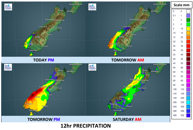
TIMELINE:
- Thursday PM: Just a few showers in Fiordland mainly
- Friday AM: Heavy rain in Fiordland creeping into South Westland and some spillover into Southland (especially the western half of Southland).
- Friday PM: Heavy rain moves slowly up the West Coast and remaining spits/patches of rain clear Southland later. A better chance of spillover into Otago, but eases there before or around midnight.
- Saturday AM: In the early hours of Saturday the front moves into Canterbury with a few showers and isolated downpours, nothing too major or widespread. Heaviest rain remains on the West Coast but is small in size and by noon the front will be falling apart.
– WeatherWatch.co.nz (an official business partner of The Weather Company & IBM)
Comments
Latest Video

ClimateWatch: MAY’s outlook as El Niño ends, NEUTRAL pattern arrives (+Video & 13 Maps)
El Niño may be technically gone but the weather pattern it created is still with our part of the world. By…
Related Articles

Thursday Newsfeed: A south-west flow across the country
A south-westerly flow has spread across NZ and will continue to do so for Thursday, Friday and Saturday. Windiest weather…
ClimateWatch: MAY’s outlook as El Niño ends, NEUTRAL pattern arrives (+Video & 13 Maps)
El Niño may be technically gone but the weather pattern it created is still with our part of the world. By…

Wednesday Newsfeed: The next southerly pounces
Snow on the southern ranges, a windier south to south-west change moving into NZ, rain around the South Island and…


Add new comment