RainWatch – Showers, heavy in spots for the North Island today.
21/10/2020 6:00pm
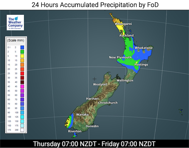
Dry for most of the South Island today, heavy showers move into Northland from the north later this morning and into the afternoon. Isolated showers develop this afternoon about Taranaki and across to Hawkes Bay / Gisborne, mainly away from coastal spots and especially about some inland hills / ranges. A few of these showers may turn heavy. Showers clear during the evening for most but about Northland showers may continue through the night with the odd isolated heavy fall still possible.
A few showers catch southern Fiordland at the other end of the country in a northwesterly airflow.
Dry for most of the South Island on Friday again, showers remain about southern Fiordland and this time a few spots may spread into Southland and Otago for a time in the evening.
The North Island has showers from Northland down through to the Central North Island, especially in the afternoon where some may become heavy with thunderstorms then easing in the evening, these showers are often inland away from the coast and especially about hills / ranges but the odd one may reach the coast in spots. Generally a dry south of about Palmerston North.
For rainfall accumulation maps for 1, 2 and 3 days out please visit our new maps page: https://www.weatherwatch.co.nz/maps-radars/rain/accumulative-rainfall
By Weather Analyst Aaron Wilkinson – WeatherWatch.co.nz
Comments
Latest Video

VIDEO: NZ – Low pressure back on the Tasman Sea menu
A high that has influenced NZ’s weather for half a month is today over the top of us – by…
Related Articles

Tuesday Newsfeed: High exits, low enters. We track the new wet weather.
High pressure that has dominated NZ’s weather pattern for over two weeks is now finally moving out to the east…
VIDEO: NZ – Low pressure back on the Tasman Sea menu
A high that has influenced NZ’s weather for half a month is today over the top of us – by…

Monday Newsfeed: High pressure crosses NZ – but brings a few showers
Milder weather will move into NZ to start this week as high pressure crosses the country, shifting winds from the…


Add new comment