RainWatch – Rain mainly out west today but a few eastern spots get lucky
18/10/2020 6:00pm
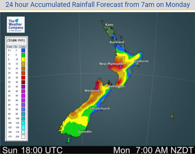
A cold front pushing north over the South Island today brings rain in the west today, heavy in some spots then easing this evening. Some rain or showers about Southland through to South Canterbury also with southwesterly winds, clearing away during the evening. Patchy showers for the west of the North Island (mainly Auckland southwards) turning to some rain south of Waikato late afternoon / evening, rain may become heavy about Taranaki for a time. Mainly dry for the eastern North Island but a few spits spread into Wairarapa from the west late afternoon / evening.
Monday’s cold front lies over the North Island on Tuesday and will weaken, expect some rain or showers in the west mostly clearing in the evening. Note that Northland is mainly dry in the map below, any early showers in the southwest clear as the front moves northwards. The east coast is mainly dry but there could be a clearing morning shower about Wairarapa. Quite dry for the South Island, a few morning showers about Southland and along the West Coast clear. There may be an isolated shower or drizzle patch in the east but I would expect it to be mainly dry overall.

Moving into Wednesday conditions are mainly dry for the North Island, a touch more warmth and surface moisture may lead to afternoon isolated showers somewhere between Auckland, Waikato and western Bay Of Plenty. It must be stressed these are quite isolated in nature and will be short in duration if showers form. Dry for the South Island, chance of some early morning drizzle in the east then clearing.

By Weather Analyst Aaron Wilkinson – WeatherWatch.co.nz
Comments
Latest Video

Tuesday Newsfeed: High exits, low enters. We track the new wet weather.
High pressure that has dominated NZ’s weather pattern for over two weeks is now finally moving out to the east…
Related Articles
Tuesday Newsfeed: High exits, low enters. We track the new wet weather.
High pressure that has dominated NZ’s weather pattern for over two weeks is now finally moving out to the east…

VIDEO: More than 1 low coming to NZ next 6 days
If you need rain then there is some (patchy) good news. A low will cross NZ on Wednesday with a…

VIDEO: NZ – Low pressure back on the Tasman Sea menu
A high that has influenced NZ’s weather for half a month is today over the top of us – by…


Add new comment