
> From the WeatherWatch archives
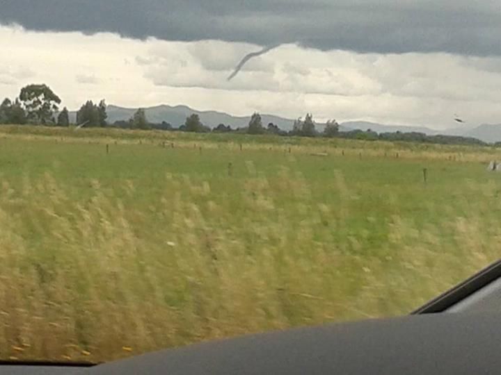
WeatherWatch.co.nz has received a photo from the Hauraki Plains south east of Auckland this afternoon, showing a narrow but dramatic looking funnel cloud.
If a funnel cloud touches the ground it becomes a tornado.
Weather conditions around the upper North Island are beginning to deteoriate this afternoon ahead of a Tasman Sea low on Sunday.
Tornados are not in the forecast today and the WeatherWatch.co.nz weekend forecast team say some afternoon heating has lead to cloud formations over some northern inland areas. It is believed to be an isolated case. The Hauraki Plains is an area known for producing funnel clouds, with steep ranges on either side the area is a basin that can lead to dramatic thunderstorms and isolated tornadoes and funnel clouds on fairly calm days, especially as warm humid breezes from the Hauraki Gulf move in.
Photo by Monique Mantell – thanks for taking the time to upload!
– WeatherWatch.co.nz
Comments
Before you add a new comment, take note this story was published on 28 Dec 2013.
Latest Video
NZ VIDEO: Polar weekend, warmer westerly gales next week
Temperatures drop this weekend nationwide as a polar change heads northwards, with Sunday the coldest of the days – ahead…
Related Articles
NZ VIDEO: Polar weekend, warmer westerly gales next week
Temperatures drop this weekend nationwide as a polar change heads northwards, with Sunday the coldest of the days – ahead…
VIDEO: More gales & downpours, sunny areas too
Another shot of polar air is coming for NZ, starting in the south on Friday and clearing the north by…
VIDEO: Milder ahead of wintry cold front, gales for Fri/Sat
Large parts of NZ will enjoy drier and more settled weather today and Thursday, ahead of windier nor-westers followed by…


Add new comment