NZ: Spring front to bring rain, gales, snow – oh, and sun! (+6 Maps)
6/11/2017 7:36pm

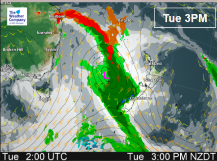
An active cold front will cross New Zealand over the next 24 hours after delivering thunderstorms and downpours to Sydney and eastern Australia yesterday.
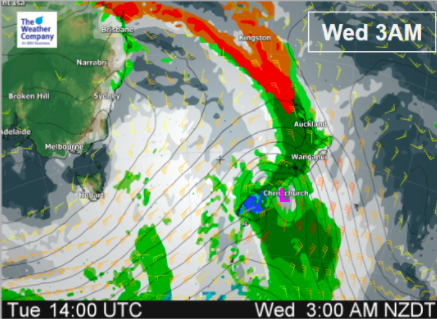
The cold front will reach the West Coast today and then cross the country overnight and into Wednesday.
The shift from warm air to cooler air will spark some heavier downpours and even a few isolated thunderstorms – although the bulk of the thunderstorms do look to occur north of the country out to sea.
Nor’West winds will be blustery to gale force with the strongest winds, predictably, around central New Zealand/Cook Strait area and in eastern areas. These winds will pick up across today pushing temperatures up after what was a colder morning in many areas this morning.
It will be cold high up too with snow falling on the South Island ranges as temperatures plummet well into the negative double digits on the summits. Lower down it won’t be so bad but Dunedin only has a high of 11 degrees on Wednesday, just 10 in Queenstown – so the air coming in is much cooler than the air flow of a week ago which saw parts of Otago and Southland climb closer to 30 degrees.
The sun will be out in force for some areas today and tomorrow too. Already today the set up means those in the east will have a hot, sunny, day before the clouds arrive.
In Hawke’s Bay today, for example, the daytime high is nudging the mid 20s. It doesn’t cool down much tomorrow or the day after either, with the coldest air brushing only the lower South Island.
The front will clear New Zealand by around noon Wednesday.


*Please not m/s = meters per second. 1 to 6 m/s = 4 to 22km/h (green). The strongest winds in these maps are orange to red shading, or 12 to 27 m/s which = 47 to 97km/h (gale force is generally above 60km/h)
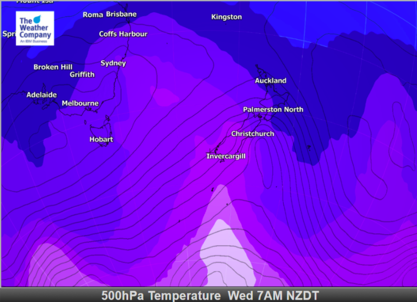
*Please note that 500hPa is about 5kms up in the sky, or just a little higher than Mt Cook. This gives us a great understanding as to how cold the air is well above the surface.
– Images / The Weather Company (an official WeatherWatch business partner)
– WeatherWatch.co.nz
Comments
Latest Video

Wednesday Newsfeed: New southern cold front as sub-tropical low tracks near north
A southern cold front moves into the South Island today & tonight while low pressure in the sub-tropics deepens north…
Related Articles
Thursday Newsfeed: Colder air heads north
A colder southerly flow is spreading up and across NZ today bringing frosty weather to inland parts of both main…

VIDEO: !Frost Alert as high pressure brings colder air, a change possible next week
Massive high pressure near Tasmania is bringing in a colder southerly for NZ today and that means frosts over the…
Wednesday Newsfeed: New southern cold front as sub-tropical low tracks near north
A southern cold front moves into the South Island today & tonight while low pressure in the sub-tropics deepens north…


Add new comment