NZ: Here come the westerlies – warmer than average for many once again (+4 Maps)
6/08/2018 8:43pm

> From the WeatherWatch archives
A cold front from the Tasman Sea is tracking towards the western side of New Zealand today after delivering a blast of wind and rain to southern Australia in recent days. The front will move onto the South Island and sweep the western side northwards to reach the North Island on Wednesday.
Heavy rainfall is expected in Westland from Tuesday night to Wednesday morning.
Up around East Cape and Gisborne and a stationary front over the north eastern tip of the North Island will decay during Tuesday. (this is not related to the Tasman Sea system moving in). Yet there will be light showery rain over parts of eastern Bay of Plenty and Gisborne until Tuesday night.
A period of briefly heavy rain or showers are possible in the upper North Island during Wednesday evening and night.
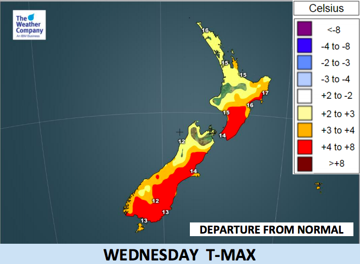
North to north west winds bring warmth to the country today and tomorrow, especially for the eastern side of both islands. Maximum temperatures in Tuesday and Wednesday will be significantly higher than usual, by several degrees.


– WeatherWatch.co.nz
Comments
Before you add a new comment, take note this story was published on 6 Aug 2018.
Latest Video
NZ 8 day outlook as high pressure moves through
High pressure will cross the South Island this weekend bringing light winds, cold nights, frosts and fog, while the North…
Related Articles
NZ 8 day outlook as high pressure moves through
High pressure will cross the South Island this weekend bringing light winds, cold nights, frosts and fog, while the North…
Eastern cloud/showers for the NI, high pressure expands elsewhere
A colder south to south-east flow will keep clouds and showers moving into some eastern parts of the North Island…
High pressure growing slowly, eastern showers for NI
A colder airflow is spreading across all of NZ now and will continue on as high pressure slowly moves towards…


Add new comment