No video today, instead we’ve dumped all our weather maps for you to see (+19 Maps!)
16/06/2019 11:39pm

We have no weather video due to sick leave so instead we’re giving you all of our maps to help make sense of what is coming in the days ahead.
This week has three distinct sections to it. The first is the southerly for Monday with a few showers. The second is incoming high pressure for Tuesday and Wednesday (with cold nights and some frosts in sheltered areas, especially the South Island). The third is a sub-tropical northerly flow later this week with a Tasman Sea low and rain moving in.
Here are some maps to make sense of it all. Our weather videos return tomorrow, Tuesday.


PRECIPITATION (RAIN + SNOW FORECASTS):

PRECIPITATION – HISTORIC:

WIND:

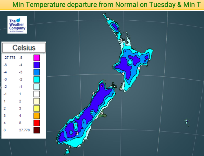
TEMPERATURES – DEPARTURE FROM NORMAL (Ie, how much warmer or colder is it comapared to this date in history):


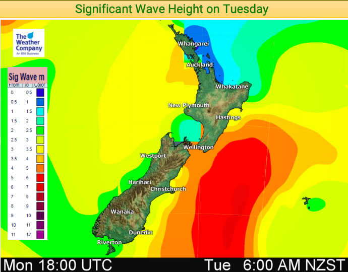
WAVE HEIGHTS:
VISIBILITY / FOG:
– WeatherWatch.co.nz
Comments
Latest Video

VIDEO: Aussie – Southern rain for SA, WA, VIC, colder NSW
A wintry southerly will drive down temperatures along the southern side of Aussie this week bringing welcome rain into dry…
Related Articles
VIDEO: Aussie – Southern rain for SA, WA, VIC, colder NSW
A wintry southerly will drive down temperatures along the southern side of Aussie this week bringing welcome rain into dry…

VIDEO: Low stuck in the NZ area all week & weekend (maybe next week too)
A large low will remain over the Tasman Sea this week before moving back over New Zealand this coming weekend….

Monday Newsfeed: Low pressure lingers all week, maybe into next week too (+9 Maps)
A large low covering much of the Tasman Sea and NZ area will remain for most of the working week…


Add new comment