
A southwesterly airflow lies over New Zealand on Monday. Expect showers in the west and far south, gradually spreading up the South Island’s east coast from afternoon.
Showers move into western parts of the North Island tomorrow morning, easing from afternoon as northwesterly winds change west to southwest. Some sun may break through at times from afternoon then later in the evening showers pick up in intensity again. Mostly sunny along the east coast, westerlies pick up in the afternoon about Wairarapa bringing a few clouds.
Morning rain eases to showers for the West Coast of the South Island, winds from the southwest. A period of morning rain or showers for Nelson / Marlborough then sunny spells break through, westerlies. Morning rain about Southland then easing to showers, westerly winds. Showers and dry spells for Otago, showers picking up and becoming more widespread from late afternoon. Canterbury has a dry morning with high cloud then afternoon showers with southerlies, showers clear at night.
Temperatures will be warmest about Northland and the east coast of the North Island with high’s getting into the early twenties. The coolest temperatures will be about the Southern Alps and Fiordland. Nelson, Marlborough and Canterbury north of Banks Peninsula sees temperatures getting into the high teens.
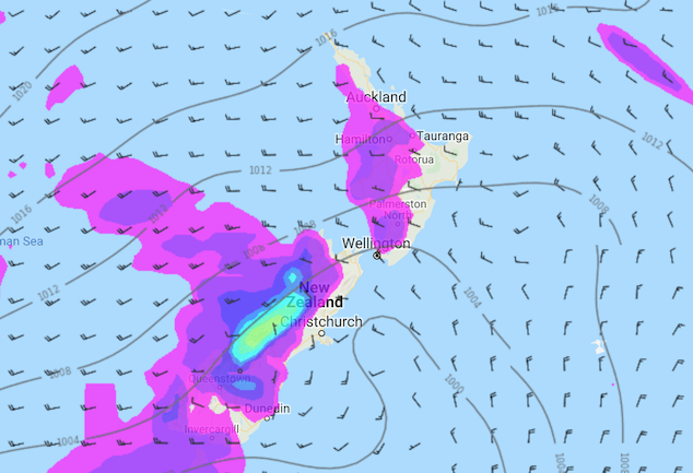
Image: Monday 21st October 2019 1:00pm MSLP / rain map – weathermap.co.nz
WeatherWatch.co.nz
Comments
Latest Video

VIDEO: Anzac Day + weather to next Tuesday
Anzac Day looks mild for many parts of NZ with windy nor’westers gusting to gale force for some. Many regions…
Related Articles

Weekend Newsfeed: Weather improves for most as high pressure drifts in
Saturday – powerful high pressure starts to move in from Australia and will still mean a few showers along the…

Anzac Day Newsfeed: Severe gales, heavy rain for some, settled for others
Updated 4am — High pressure over northern NZ moves east of the country on Thursday while a storm south of…
VIDEO: Anzac Day + weather to next Tuesday
Anzac Day looks mild for many parts of NZ with windy nor’westers gusting to gale force for some. Many regions…


Add new comment