InfoGraphic: The main Weather News Highlights across NZ: Wed, Thu, Fri
4/04/2017 6:03pm

A low moves towards the west of the North Island today then pushes eastwards overnight. Northerlies for most of the North Island, a southeasterly airflow for the South Island and about Wellington / Wairarapa. This low passes out to the east of the country on Thursday and the airflow changes around to the southerly quarter for the South Island, westerlies for the North Island. Friday sees a relative moment of peace in a cool southwesterly airflow.
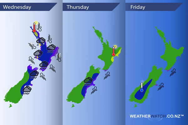
Wednesday
Blue – Areas of heavy rain across many regions during the day, not becoming heavy about Canterbury till evening in the north then further south overnight. A few parts of the upper North Island may see thunderstorms from afternoon, perhaps even the low risk of a small tornado about western coastal fringes. Taranaki in particular may see heavy rain for much of the day including thunderstorms in the afternoon.
Purple – Gusty northerlies about northern parts of the North Island during the day. Strong east to southeasterly winds about central New Zealand during the day, winds may gust to gale at times. Severe gales possible about northern Tasman and the Marlborough Sounds, also through Cook Strait. Overnight as a low starts to move over strong southwesterly winds develop about the east coast of the South Island and strong northwesterlies move into the west of the North Island.
Yellow – Afternoon high’s may just reach into the mid 20’s for parts of Northland and Gisborne.
Thursday
Blue – Areas of heavy rain about eastern parts of the South Island ease from afternoon.
Purple – About the east coast of the South Island expect strong to gale southwest winds, about Banks Peninsula from morning and elsewhere along the coast from afternoon. Severe gales possible for some coastal fringes especially Banks Peninsula. A small part of the lower North Island may see strong southwesterlies during the day also.
Yellow – High’s reaching into the mid 20’s during the afternoon for Hawkes Bay and Gisborne.
Friday
Blue – A frosty start about the central South Island, temperatures may dip down to around -1 or perhaps even -2 degrees celcius around dawn.
Purple – Remaining strong coastal southwesterly winds ease away during the morning.
– Please note, the idea behind this update is to focus on the main weather highlights, which is why not all regions are mentioned.
For specific 10 day information for your city, town, rural community or island please see the 1500 forecasts on our homepage!
– Aaron Wilkinson, WeatherWatch.co.nz
Comments
Latest Video

VIDEO: Wintry weather in the south, showers continue in the north
Saturday will feel like winter in the lower South Island but northerners will be under high pressure and lighter winds….
Related Articles

Weekend Newsfeed: Winter weather in the south, high pressure in the north
A cold change is about to reach the lower half of the South Island bringing snow to the hills and…
VIDEO: Wintry weather in the south, showers continue in the north
Saturday will feel like winter in the lower South Island but northerners will be under high pressure and lighter winds….

Thursday Newsfeed: Autumnal weather means highs, lows & cold fronts
A windy sou’wester kicks in for northern NZ on Thursday while a cold southerly arrives in the lower South Island…


Add new comment