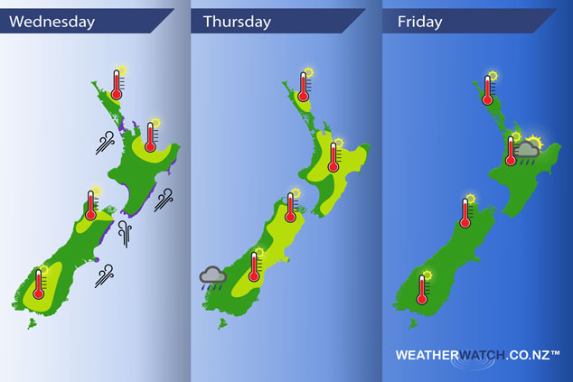
InfoGraphic: The Main Weather News Highlights across NZ: Wed, Thu, Fri
19/12/2017 6:00pm

A gusty southwesterly airflow eases over New Zealand today while a ridge moves onto the South Island. Another front lines up the South Island for Thursday while it’s mainly settled further north. Mainly settled for most on Friday.
Wednesday
Yellow – Afternoon high’s reaching into the mid twenties today for parts of the upper North Island, also some South Island areas.
Purple – Strong south to southwesterly winds about eastern areas (mainly the coastal fringes), easing later in the day. Winds are also gusty / strong about Auckland this afternoon then easing later this evening.
Thursday
Yellow – Temperatures reaching into the mid to late twenties for the eastern South Island northwards.
Some rain pushes into South Westland during the morning, it may be briefly heavy for a time.
Friday
Warm afternoon temperatures for the lower South Island, also about inland Buller. The western / upper North Island sees the hottest temperatures reaching into the late twenties. A few isolated heavy showers may develop late afternoon / evening about the inner North Island.
– Please note, the idea behind this update is to focus on the main weather highlights, which is why not all regions are mentioned.
For specific 10 day information for your city, town, rural community or island please see the 1500 forecasts on our homepage!
– Aaron Wilkinson, WeatherWatch.co.nz
Comments
Latest Video

Sunday Newsfeed: Low pressure areas increase offshore near northern NZ in days ahead
A light easterly kicks in to the north of the North Island on Sunday as high pressure moves south east…
Related Articles
Sunday Newsfeed: Low pressure areas increase offshore near northern NZ in days ahead
A light easterly kicks in to the north of the North Island on Sunday as high pressure moves south east…

VIDEO: 7 Day NZ RainWatch: Who gets rain, who misses out
A cold front will bring winter-like weather into the lower South Island on Saturday but won’t make to the top…

MetService Auckland rain radar offline – helicopter called in
Aucklanders may have noticed the rain radar isn’t working this week. MetService has provided us with an update ahead of…


Add new comment