InfoGraphic: The Main Weather News Highlights across NZ: Wed, Thu, Fri
5/12/2017 6:00pm

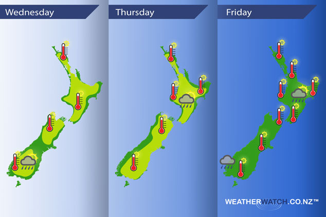
Mainly settled and hot weather continues today and Thursday due to an anticyclone, a northerly airflow develops on Friday.
Wednesday
Yellow – Looking hot for most places across the country with high’s in the late twenties, early thirties is possible for some inland North Island spots. The east coast of the South Island gets a slight reprieve due to some cloud cover.
A few isolated showers possible about Central Otago late afternoon / evening.
Thursday
Yellow – A hot day on the cards with high’s in the mid to late twenties for most, especially just away from the coast. Early thirties for inland valleys and basins of the South Island, also inland parts of the North Island.
Watch for the chance of an isolated shower late afternoon / evening about inland parts of the lower North Island.
Friday
The run of hot weather continues especially in the east of the South Island where early thirty degree temperatures are looking likely. Isolated showers may spring up again for inland parts of the North Island and about Fiordland there may be some heavy rain during the day.
– Please note, the idea behind this update is to focus on the main weather highlights, which is why not all regions are mentioned.
For specific 10 day information for your city, town, rural community or island please see the 1500 forecasts on our homepage!
– Aaron Wilkinson, WeatherWatch.co.nz
Comments
Latest Video

Sunday Newsfeed: Low pressure areas increase offshore near northern NZ in days ahead
A light easterly kicks in to the north of the North Island on Sunday as high pressure moves south east…
Related Articles
Sunday Newsfeed: Low pressure areas increase offshore near northern NZ in days ahead
A light easterly kicks in to the north of the North Island on Sunday as high pressure moves south east…

VIDEO: 7 Day NZ RainWatch: Who gets rain, who misses out
A cold front will bring winter-like weather into the lower South Island on Saturday but won’t make to the top…

MetService Auckland rain radar offline – helicopter called in
Aucklanders may have noticed the rain radar isn’t working this week. MetService has provided us with an update ahead of…


Add new comment