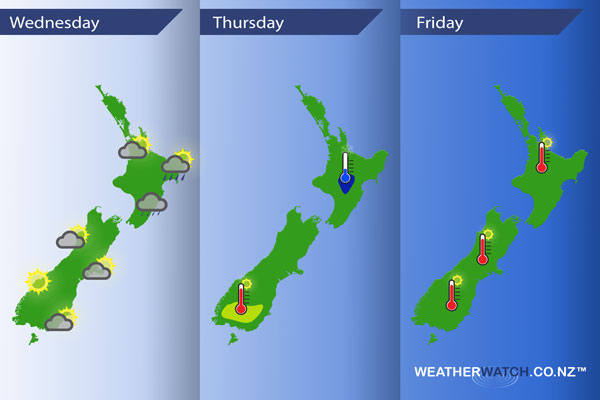
InfoGraphic: The Main Weather News Highlights across NZ: Wed, Thu, Fri
17/10/2017 6:00pm

A ridge moves onto the South Island today while a southerly airflow lies over the North Island. A ridge covers most of the country on Thursday spreading out from a high in the Tasman Sea. Still mostly high pressure on Friday although it will weaken during the day as a northwesterly airflow gradually builds over the lower South Island. A front moves onto Southland overnight.
Wednesday
Not a lot happening today as a ridge of high pressure starts to move in. Cloud spreads northwards for the east of the North Island this morning bringing patchy showers or drizzle. Sunny for the West Coast of the South Island after any morning cloud clears, morning cloud clears the lower South Island then mainly sunny. Fairly cloudy from Canterbury through to Nelson with a morning shower or two gradually clearing away, some sun may break through from afternoon about Canterbury.
Thursday
Blue – Only a slight risk of a light frost about the Central North Island in the morning
Yellow – Afternoon temperatures reaching into the low 20’s across many parts of the South Island especially inland. The lower South Island (Southland and inland Otago) may see late afternoon temperatures reaching into the mid to late 20’s.
Friday
High’s reaching into the low 20’s across many inland parts of New Zealand on Friday, mid 20’s is possible mainly about inland eastern Otago / Southland.
– Please note, the idea behind this update is to focus on the main weather highlights, which is why not all regions are mentioned.
For specific 10 day information for your city, town, rural community or island please see the 1500 forecasts on our homepage!
– Aaron Wilkinson, WeatherWatch.co.nz
Comments
Latest Video

VIDEO: High pressure to cross NZ, but a westerly change behind it
Colder air takes us into the weekend but next week milder sub-tropical winds and westerlies are likely as high pressure…
Related Articles

The solar winter has begun… the 3 darkest months of the year
While we’re still in Autumn the “Solar Winter” has just begun – the second week of May marks the three…

Thursday Newsfeed: Colder air heads north
A colder southerly flow is spreading up and across NZ today bringing frosty weather to inland parts of both main…
VIDEO: High pressure to cross NZ, but a westerly change behind it
Colder air takes us into the weekend but next week milder sub-tropical winds and westerlies are likely as high pressure…


Add new comment