InfoGraphic: The Main Weather News Highlights across NZ: Wed, Thu, Fri
3/10/2017 6:00pm

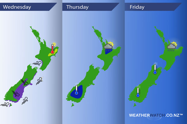
A northwesterly airflow develops over the South Island today then changing cooler southwest about the lower South Island this afternoon, reaching the lower North Island overnight. A high moves over the country on Thursday then hangs around for much of Friday while a low brews in the Tasman Sea.
Wednesday
Purple – Northwesterly winds strengthen about the inner South Island from this morning then in the afternoon winds change gusty southwest, winds strong about coastal areas then pushing northwards in the evening.
Westerlies brisk about coastal parts of the lower western North Island during the day.
Yellow – Temperatures may approach the mid 20’s in the afternoon about Hawkes Bay (mainly inland) and Gisborne.
Thursday
Blue – Potentially a frosty start about the lower South Island in the morning (inland), only the risk of a light frost however this may be of concern to growers.
In the afternoon / evening there may be a few heavy isolated showers about the Waikato / Bay Of Plenty then easing later.
Friday
Still the chance of a light frost again on Friday morning, only just, for inner parts of the South Island. Low risk of a heavy isolated shower about some upper North Island areas in the afternoon.
– Please note, the idea behind this update is to focus on the main weather highlights, which is why not all regions are mentioned.
For specific 10 day information for your city, town, rural community or island please see the 1500 forecasts on our homepage!
– Aaron Wilkinson, WeatherWatch.co.nz
Comments
Latest Video

Sunday Newsfeed: Low pressure areas increase offshore near northern NZ in days ahead
A light easterly kicks in to the north of the North Island on Sunday as high pressure moves south east…
Related Articles
Sunday Newsfeed: Low pressure areas increase offshore near northern NZ in days ahead
A light easterly kicks in to the north of the North Island on Sunday as high pressure moves south east…

VIDEO: 7 Day NZ RainWatch: Who gets rain, who misses out
A cold front will bring winter-like weather into the lower South Island on Saturday but won’t make to the top…

MetService Auckland rain radar offline – helicopter called in
Aucklanders may have noticed the rain radar isn’t working this week. MetService has provided us with an update ahead of…


Add new comment