InfoGraphic: The Main Weather News Highlights across NZ: Wed, Thu, Fri
1/08/2017 7:00pm

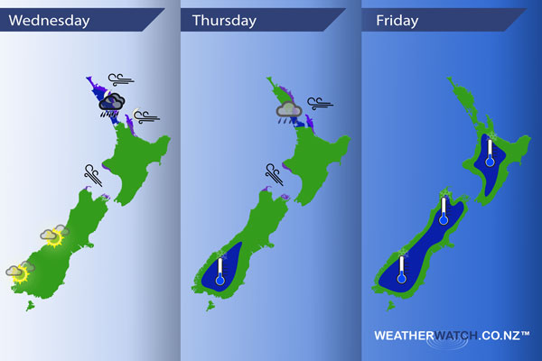
A large low sits west of New Zealand in the Tasman Sea today dragging in a cool southerly airflow for much of New Zealand, east to northeast winds for the upper North Island however. A front moves onto Northland during the afternoon then pushes a little further south overnight. A ridge starts to make some headway over the South Island on Thursday, easterly quarter winds ease further north. A ridge covers most of the country on Friday.
Wednesday
Blue – As a front moves in from the Tasman Sea with it comes some heavy rain, pushing into Northland during the afternoon then moving a little further south overnight.
Purple – Easterly winds becoming gusty about eastern Northland from afternoon then further south overnight. Southeasterlies build through Cook Strait from afternoon becoming gusty.
A nice day for the West Coast of the South Island, dry with some high cloud.
Thursday
Blue – Morning rain (possibly heavy) about Auckland / Northland eases then clears away.
A frosty start about the lower South Island inland.
Purple – Gusty east to southeasterly winds ease later in the day.
Friday
A frosty start about inland parts of both Islands, heaviest about the inner South Island.
– Please note, the idea behind this update is to focus on the main weather highlights, which is why not all regions are mentioned.
For specific 10 day information for your city, town, rural community or island please see the 1500 forecasts on our homepage!
– Aaron Wilkinson, WeatherWatch.co.nz
Comments
Latest Video

Sunday Newsfeed: Low pressure areas increase offshore near northern NZ in days ahead
A light easterly kicks in to the north of the North Island on Sunday as high pressure moves south east…
Related Articles
Sunday Newsfeed: Low pressure areas increase offshore near northern NZ in days ahead
A light easterly kicks in to the north of the North Island on Sunday as high pressure moves south east…

VIDEO: 7 Day NZ RainWatch: Who gets rain, who misses out
A cold front will bring winter-like weather into the lower South Island on Saturday but won’t make to the top…

MetService Auckland rain radar offline – helicopter called in
Aucklanders may have noticed the rain radar isn’t working this week. MetService has provided us with an update ahead of…


Add new comment