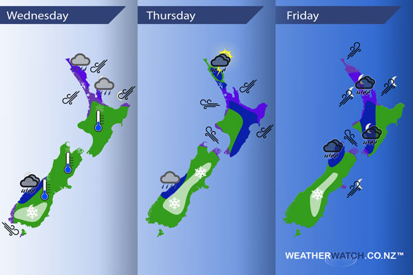
InfoGraphic: The Main Weather News Highlights across NZ: Wed, Thu, Fri
20/06/2017 7:00pm

A ridge weakens over New Zealand today then a front slowly moves southwards over the upper North Island later this evening, a cold front moves onto the lower South Island later in the evening / overnight. This cold front combines with a warm front coming out of a low in the Tasman Sea on Thursday over central South Island regions and may deliver some warm advection snow to inland areas. Meanwhile an occluded front continues to move southwards over the North Island during the day. A low pressure system moves over the North Island on Friday with an easterly quarter airflow over the country tending southwest later in the day.
Wednesday
Blue – From late afternoon heavy showers may start to affect Northland then slowly slipping southwards through to Coromandel overnight.
Overnight rain about South Westland will be heavy for a time.
A tad frosty to start the day about some South Island areas this morning, not a very uniform frost however we have a scattering of -1 to -3 degree readings, even a few -4 to -6 degree readings about Mount Cook through to Omarama.
White – A cold front pushes onto the lower South Island later in the evening then moves into Otago overnight, this front carries with it fairly cold air so some snow may develop to 400m or perhaps even 300m for a time however it is looking to be fairly brief at this stage then easing or perhaps clearing around dawn on Thursday for Southland as this frontal feature moves northwards.
Purple – East to northeasterly winds about Northland and Auckland are fairly gusty, moving a little further southwards in the evening.
A pre frontal northwest airflow becomes gusty about coastal parts of the lower South Island from morning then easing later in the afternoon.
Thursday
Blue – Areas of heavy rain / showers ease about Auckland and the Waikato afternoon onwards, perhaps more towards evening for the Bay Of Plenty. For the east coast of the North Island rain / showers becoming heavy by midday.
In the afternoon heavy showers / downpours may develop about Northland, perhaps even a thunderstorm then easing in the evening.
Morning heavy rain / showers eases about South Westland.
White – Warm advection snow sets up about the inner South Island from North Otago in the morning through to North Canterbury afternoon onwards. Snow isn’t looking overly heavy for Thursday however it will still be of concern to travellers and farmers, ski fields will be welcoming of the snow.
Snow lowering to 400m about North Otago / South Canterbury during the morning although it may back off from afternoon in terms of intensity however the air will still be cold. Starting out higher about Mid Canterbury then lowering to 500m in the afternoon. Snow lowering to 600m about North Canterbury by evening.
Purple – Gusty easterly quarter winds for North Island regions, mostly easing from afternoon. Strong southeasterlies with a risk of gales developing through Cook Strait afternoon onwards.
Friday
Blue – Rain may be heavy about Buller / Tasman during the day then easing in the evening. Overnight as a strong southwesterly airflow develops there may be some heavy rain about western North Island regions.
White – Snow flurries continue about the interior of the South Island for much of the day, not clearing till overnight. However the levels will be higher. Falling to about 500m in the morning about South Canterbury / North Otago, 800m for North Canterbury, lifting above 1000m in the afternoon about North Canterbury and lifting above 1000m overnight further south before clearing.
Purple – Strong southeasterlies through Cook Strait tend more southerly at night. A strong southwesterly airflow develops about Northland in the afternoon then spreading southwards into Auckland, Waikato and Bay Of Plenty overnight. Southwesterlies may gust to gale at times especially about coastal areas in the west.
Overnight gusty southwesterlies develop about outer parts of Banks Peninsula also.
– Please note, the idea behind this update is to focus on the main weather highlights, which is why not all regions are mentioned.
For specific 10 day information for your city, town, rural community or island please see the 1500 forecasts on our homepage!
– Aaron Wilkinson, WeatherWatch.co.nz
Comments
Latest Video

Weekend Newsfeed: Winter weather in the south, high pressure in the north
A cold change is affecting the lower half of the South Island Saturday bringing snow to the hills and ranges…
Related Articles
Weekend Newsfeed: Winter weather in the south, high pressure in the north
A cold change is affecting the lower half of the South Island Saturday bringing snow to the hills and ranges…

VIDEO: 7 Day NZ RainWatch: Who gets rain, who misses out
A cold front will bring winter-like weather into the lower South Island on Saturday but won’t make to the top…

MetService Auckland rain radar offline – helicopter called in
Aucklanders may have noticed the rain radar isn’t working this week. MetService has provided us with an update ahead of…


Add new comment
Jessica on 20/06/2017 8:23pm
What are the chances are snow to lower levels around the Central Plateau on Friday / Saturday?
Reply
WW Forecast Team on 20/06/2017 11:24pm
Hi Jessica – there are some chances of snow in Central Plateau this Friday night and Saturday – mostly in the form of snow showers coming through. While some snow is possible in places like the Desert Road and Ohakune area we don’t anticipate it to be a lot at those lower levels. The mountains should get a nice dusting especially on the south and western sides on Friday night or over Saturday as the colder SW flow kicks in after this relatively mild NE flow at the moment.
Kind regards
WW
Reply
Jessica on 21/06/2017 12:35am
Perfect, just the news I wanted to hear! thanks.
Reply