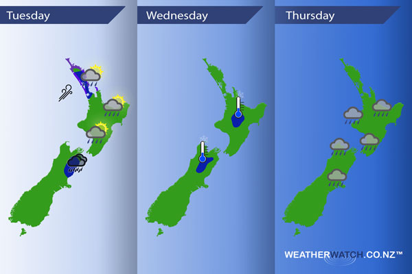
InfoGraphic: The Main Weather News Highlights across NZ: Tue, Wed, Thu
18/09/2017 7:00pm

A cold south to southwesterly airflow eases during today meanwhile a slim ridge of high pressure starts to move onto the South Island. A ridge for the North Island on Wednesday while northeasterlies increase further south. A front pushes onto the country overnight from the west then a low moves in on Thursday.
Tuesday
Blue – Early heavy showers ease for Northland / Auckland.
Morning heavy rain about the Kaikoura area eases.
Purple – Gusty southwesterlies quickly ease about Northland and Auckland during the morning.
Wednesday
Blue – Potential for a light frost to start the day about some inland areas in the morning.
Thursday
As a front moves over New Zealand from the west early on Thursday there may be a few heavy showers embedded in it.
– Please note, the idea behind this update is to focus on the main weather highlights, which is why not all regions are mentioned.
For specific 10 day information for your city, town, rural community or island please see the 1500 forecasts on our homepage!
– Aaron Wilkinson, WeatherWatch.co.nz
Comments
Latest Video

Sunday Newsfeed: Low pressure areas increase offshore near northern NZ in days ahead
A light easterly kicks in to the north of the North Island on Sunday as high pressure moves south east…
Related Articles
Sunday Newsfeed: Low pressure areas increase offshore near northern NZ in days ahead
A light easterly kicks in to the north of the North Island on Sunday as high pressure moves south east…

VIDEO: 7 Day NZ RainWatch: Who gets rain, who misses out
A cold front will bring winter-like weather into the lower South Island on Saturday but won’t make to the top…

MetService Auckland rain radar offline – helicopter called in
Aucklanders may have noticed the rain radar isn’t working this week. MetService has provided us with an update ahead of…


Add new comment