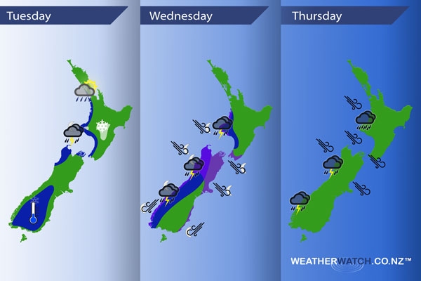
InfoGraphic: The Main Weather News Highlights across NZ: Tue, Wed, Thu
14/08/2017 7:00pm

A westerly quarter airflow lies over the North Island today, an early morning trough moves through from the west then overnight another frontal feature barrels in from the Tasman Sea to western parts of the North Island and upper / western South Island. The South Island in general for much of today sees calmer weather with southwesterlies easing during the morning. A northerly quarter airflow strengthens later on Wednesday then a strong front moves over the South Island overnight, pushing over the North Island on Thursday.
Tuesday
Blue – Showers about western fringes of the North Island may be heavy at times with a risk of hail / thunder this morning then gradually easing during the day.
Overnight a band of rain moves in, heavy with possible thunderstorms and hail, especially about Taranaki southwards. Also parts of the upper South Island, Tasman and the Marlborough Sounds.
A frosty start this morning about lower / inner parts of the South Island. Temperatures may start the day around -4 degrees for some.
White – Snow flurries about the Central Plateau to 800m.
Wednesday
Blue – A band of rain may bring heavy falls and thunderstorms to the western North Island on Wednesday morning then gradually easing.
Later in the evening / overnight heavy rain moves onto the West Coast of the South Island bringing thunderstorms. Rain may become torrential overnight.
Purple – Northeasterlies becoming strong about coastal South Westland and coastal Otago from evening then easing overnight. Strong northwesterlies overnight for much of the upper South Island, gales likely in exposed areas and through Cook Strait.
Thursday
Heavy rain eases in the morning along the West Coast however from afternoon showers may become heavy again at times with a risk of thunderstorms. Some heavy rain moves into the western North Island during the morning then easing by evening. Strong to gale northwesterlies about the upper South Island and lower North Island ease during the afternoon.
– Please note, the idea behind this update is to focus on the main weather highlights, which is why not all regions are mentioned.
For specific 10 day information for your city, town, rural community or island please see the 1500 forecasts on our homepage!
– Aaron Wilkinson, WeatherWatch.co.nz
Comments
Latest Video

Sunday Newsfeed: Low pressure areas increase offshore near northern NZ in days ahead
A light easterly kicks in to the north of the North Island on Sunday as high pressure moves south east…
Related Articles
Sunday Newsfeed: Low pressure areas increase offshore near northern NZ in days ahead
A light easterly kicks in to the north of the North Island on Sunday as high pressure moves south east…

VIDEO: 7 Day NZ RainWatch: Who gets rain, who misses out
A cold front will bring winter-like weather into the lower South Island on Saturday but won’t make to the top…

MetService Auckland rain radar offline – helicopter called in
Aucklanders may have noticed the rain radar isn’t working this week. MetService has provided us with an update ahead of…


Add new comment