InfoGraphic: The Main Weather News Highlights across NZ: Thu, Fri, Sat
25/10/2017 6:00pm

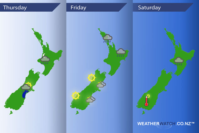
A westerly airflow lies over New Zealand today, a weak front straddles the upper North Island while another fairly weak front moves onto the lower South Island this afternoon. A front lingers over the North Island on Friday and Saturday while a ridge lies over the South Island.
Thursday
Blue – This evening a few heavy isolated showers may develop about South Canterbury then easing overnight.
Overnight showers move onto the western North Island, there may be a few isolated heavy areas of rain within these showers.
Friday
A narrow band of showers lies from about Auckland across to Gisborne on Friday, there is a chance there may be an isolated heavy fall or two along this band at times in the afternoon and evening.
For the South Island it’s looking like a mainly sunny day in the south, west and north while Canterbury and eastern Otago has cloudy areas and the risk of a light shower or two in the morning.
Saturday
A showery morning for the upper North Island then a weak front that is generating these showers slowly slinks southwards during the day bringing showers or areas of rain to the lower North Island.
Warm afternoon temperatures for inland Southland / Otago, temperatures may approach the mid 20’s.
– Please note, the idea behind this update is to focus on the main weather highlights, which is why not all regions are mentioned.
For specific 10 day information for your city, town, rural community or island please see the 1500 forecasts on our homepage!
– Aaron Wilkinson, WeatherWatch.co.nz
Comments
Latest Video

Wednesday Newsfeed: New southern cold front as sub-tropical low tracks near north
A southern cold front moves into the South Island today & tonight while low pressure in the sub-tropics deepens north…
Related Articles

VIDEO: !Frost Alert as high pressure brings colder air, a change possible next week
Massive high pressure near Tasmania is bringing in a colder southerly for NZ today and that means frosts over the…
Wednesday Newsfeed: New southern cold front as sub-tropical low tracks near north
A southern cold front moves into the South Island today & tonight while low pressure in the sub-tropics deepens north…

VIDEO: Frosts, colder nights, showers & high pressure
High pressure is to the south-west of NZ, low pressure to the north-east – this creates a colder southerly quarter…


Add new comment