InfoGraphic: The Main Weather News Highlights across NZ: Thu, Fri, Sat
2/08/2017 7:00pm

A gusty east to southeasterly airflow eases over the North Island later today meanwhile a ridge starts to make some headway over the South Island. A ridge covers most of the country on Friday then a northerly quarter airflow increases on Saturday ahead of a front which moves onto the West Coast of the South Island later in the evening / overnight.
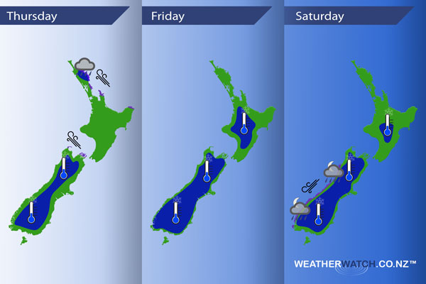
Thursday
Blue – Morning rain (possibly heavy) about Northland and northern Auckland eases.
A frosty start about the South Island inland.
Purple – Gusty east to southeasterly winds ease later in the day.
Friday
Blue – A frosty start about inland parts of both Islands, heaviest about the inner / lower South Island.
Saturday
Another frosty start in the morning although not as bad as Friday morning. A north to northeasterly airflow increases over the South Island during the day, winds becoming gusty / strong about coastal fringes of South Westland from afternoon.
Overnight rain moves onto the West Coast of the South Island which may be heavy in areas.
– Please note, the idea behind this update is to focus on the main weather highlights, which is why not all regions are mentioned.
For specific 10 day information for your city, town, rural community or island please see the 1500 forecasts on our homepage!
– Aaron Wilkinson, WeatherWatch.co.nz
Comments
Latest Video

Sunday Newsfeed: Low pressure areas increase offshore near northern NZ in days ahead
A light easterly kicks in to the north of the North Island on Sunday as high pressure moves south east…
Related Articles
Sunday Newsfeed: Low pressure areas increase offshore near northern NZ in days ahead
A light easterly kicks in to the north of the North Island on Sunday as high pressure moves south east…

VIDEO: 7 Day NZ RainWatch: Who gets rain, who misses out
A cold front will bring winter-like weather into the lower South Island on Saturday but won’t make to the top…

MetService Auckland rain radar offline – helicopter called in
Aucklanders may have noticed the rain radar isn’t working this week. MetService has provided us with an update ahead of…


Add new comment