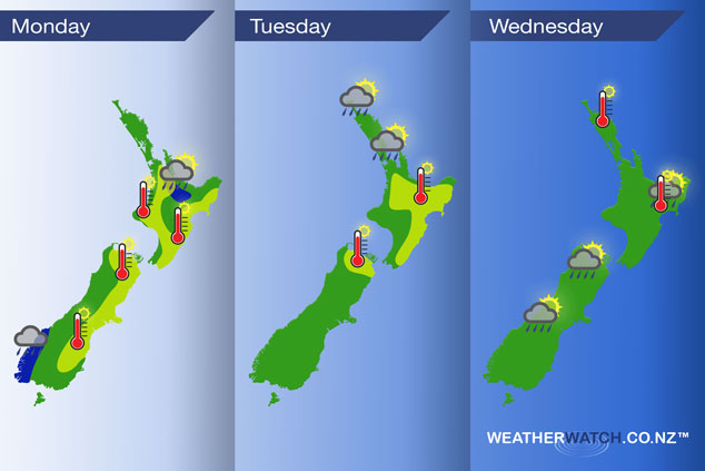
InfoGraphic: The Main Weather News Highlights across NZ: Mon, Tue, Wed
10/12/2017 6:00pm

A northwesterly airflow lies over New Zealand today, a few weak frontal zones sit over the North Island while a stronger front affects the far south.The front about the far south moves slowly over the South Island on Tuesday, weakening as it goes while a southwest airflow lies over the North Island on Tuesday and Wednesday.
Monday
Blue – Some heavy rain affects Fiordland, easing by this evening. A period of showers moves through Waikato and inland Bay Of Plenty this afternoon / evening, some may be heavy with the low risk of a thunderstorm.
Yellow – Afternoon high’s today ranging from the mid twenties through to the high twenties. Perhaps even early thirties for some isolated spots just inland away from the coast in Canterbury.
Tuesday
Isolated showers possible in the afternoon / evening for Northland and Auckland, one or two may be heavy then clearing in he evening.
Yellow – Afternoon high’s in the early to mid twenties on Tuesday, perhaps early thirties along the North Island’s East coast.
Wednsesday
– Showers may become heavy about the interior of both Islands on Wednesay afternoon then easing in the evening. Temperatures reaching into the mid twenties for some upper and eastern parts of the North Island.
– Please note, the idea behind this update is to focus on the main weather highlights, which is why not all regions are mentioned.
For specific 10 day information for your city, town, rural community or island please see the 1500 forecasts on our homepage!
– Aaron Wilkinson, WeatherWatch.co.nz
Comments
Latest Video

Sunday Newsfeed: Low pressure areas increase offshore near northern NZ in days ahead
A light easterly kicks in to the north of the North Island on Sunday as high pressure moves south east…
Related Articles
Sunday Newsfeed: Low pressure areas increase offshore near northern NZ in days ahead
A light easterly kicks in to the north of the North Island on Sunday as high pressure moves south east…

VIDEO: 7 Day NZ RainWatch: Who gets rain, who misses out
A cold front will bring winter-like weather into the lower South Island on Saturday but won’t make to the top…

MetService Auckland rain radar offline – helicopter called in
Aucklanders may have noticed the rain radar isn’t working this week. MetService has provided us with an update ahead of…


Add new comment