InfoGraphic: The Main Weather News Highlights across NZ: Mon, Tue, Wed
1/10/2017 6:00pm

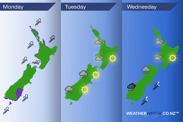
A strong southwesterly airflow gradually eases during the day today. A southwesterly airflow continues to push through on Tuesday then on Wednesday tending westerly ahead of a front later in the day.
Monday
Purple – Strong southwesterly winds for many parts of New Zealand today, gradually easing during the day for most although winds may gust to gale at times for coastal areas into the afternoon.
Tuesday
A generic southwesterly airflow brings cloudy areas to western regions on Tuesday, perhaps a shower or two also especially for the South Island’s West Coast in the morning. Sunnier out east.
Wednesday
Rain moves into South Westland during the afternoon with heavy falls possible, reaching North Westland in the evening however conditions may have eased a little. Later in the evening then overnight a strong southwest change pushes northwards along the South Island’s East Coast.
Cloudy areas for the west of the North Island during the day, sunnier in the east with warm afternoon temperatures.
– Please note, the idea behind this update is to focus on the main weather highlights, which is why not all regions are mentioned.
For specific 10 day information for your city, town, rural community or island please see the 1500 forecasts on our homepage!
– Aaron Wilkinson, WeatherWatch.co.nz
Comments
Latest Video

Sunday Newsfeed: Low pressure areas increase offshore near northern NZ in days ahead
A light easterly kicks in to the north of the North Island on Sunday as high pressure moves south east…
Related Articles
Sunday Newsfeed: Low pressure areas increase offshore near northern NZ in days ahead
A light easterly kicks in to the north of the North Island on Sunday as high pressure moves south east…

VIDEO: 7 Day NZ RainWatch: Who gets rain, who misses out
A cold front will bring winter-like weather into the lower South Island on Saturday but won’t make to the top…

MetService Auckland rain radar offline – helicopter called in
Aucklanders may have noticed the rain radar isn’t working this week. MetService has provided us with an update ahead of…


Add new comment