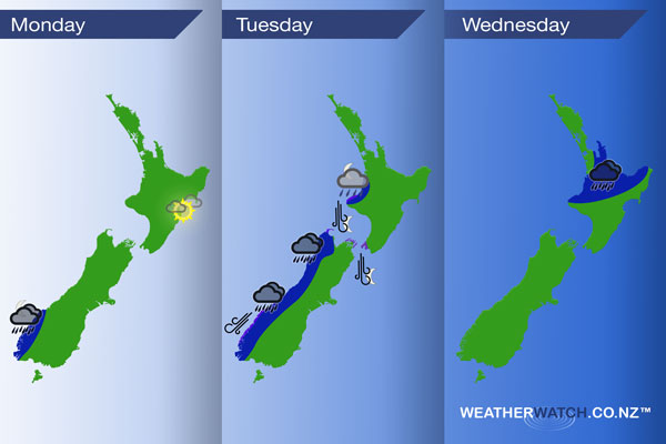
InfoGraphic: The Main Weather News Highlights across NZ: Mon, Tue, Wed
6/08/2017 7:00pm

A northwesterly airflow lies over New Zealand today, within this flow a frontal zone over the upper North Island weakens during the day. Northerlies on Tuesday with a front pushing into western regions late afternoon / evening, this front lies over the North Island on Wednesday meanwhile conditions are more settled further south.
Monday
Blue – Rain about Fiordland may be heavy at times this evening.
A warm day in the east, afternoon high’s may reach 20 degrees about the North Island’s east coast.
Tuesday
Blue – Late afternoon or evening some rain moves onto the West Coast of the South Island bringing a chance of heavy falls. Later in the evening / overnight some heavy rain is possible about northern Taranaki.
Purple – Gusty northeasterlies about coastal Fiordland from afternoon, easing overnight. Northerlies about coastal Taranaki, the top of the South Island and through Cook Strait becoming gusty in the evening. Winds may gust to gale at times.
Wednesday
Rain about some parts of the upper North Island may be heavy from afternoon then easing later in the evening.
– Please note, the idea behind this update is to focus on the main weather highlights, which is why not all regions are mentioned.
For specific 10 day information for your city, town, rural community or island please see the 1500 forecasts on our homepage!
– Aaron Wilkinson, WeatherWatch.co.nz
Comments
Latest Video

Sunday Newsfeed: Low pressure areas increase offshore near northern NZ in days ahead
A light easterly kicks in to the north of the North Island on Sunday as high pressure moves south east…
Related Articles
Sunday Newsfeed: Low pressure areas increase offshore near northern NZ in days ahead
A light easterly kicks in to the north of the North Island on Sunday as high pressure moves south east…

VIDEO: 7 Day NZ RainWatch: Who gets rain, who misses out
A cold front will bring winter-like weather into the lower South Island on Saturday but won’t make to the top…

MetService Auckland rain radar offline – helicopter called in
Aucklanders may have noticed the rain radar isn’t working this week. MetService has provided us with an update ahead of…


Add new comment