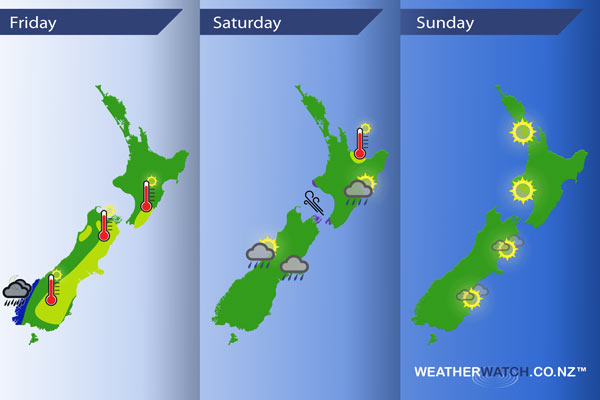
InfoGraphic: The main Weather News Highlights across NZ: Fri, Sat, Sun
16/03/2017 6:00pm

Northwesterlies develop over the South Island today while a ridge lies over the North Island, a front moves onto the lower South Island later this evening. This front moves northwards over the country on Saturday however it weakens quite fast due to another incoming high. A ridge lies over most of the country on Sunday.
Friday
Blue – Rain about Fiordland later in the evening and for a time overnight may be heavy.
Yellow – Afternoon high’s in the mid to high 20’s for the east of New Zealand due to a northwesterly airflow.
Saturday
Purple – Early afternoon gusty south to southeasterly winds push through Cook Strait and move up to coastal Taranaki in the south then easing later in the evening.
Yellow – High’s may reach into the mid 20’s for parts of the Bay Of Plenty in the afternoon.
As a front moves northwards over New Zealand on Saturday it weakens a fair amount, it will bring cloudy areas to the east of the South Island from morning, also a few morning showers or drizzle patches. A sunny start for the east of the North Island then cloud and gradually drizzle develops in the afternoon as southerlies freshen.
Sunday
The best weather on Sunday looks to be the east of the South Island, perhaps a touch of high cloud, winds mainly light and afternoon high’s in the low 20’s. Sunny for the west of the North Island with winds from the southerly quarter, high’s also reaching into the low 20’s.
– Please note, the idea behind this update is to focus on the main weather highlights, which is why not all regions are mentioned.
For specific 10 day information for your city, town, rural community or island please see the 1500 forecasts on our homepage!
– Aaron Wilkinson, WeatherWatch.co.nz
Comments
Latest Video

Tuesday Newsfeed: High exits, low enters. We track the new wet weather.
High pressure that has dominated NZ’s weather pattern for over two weeks is now finally moving out to the east…
Related Articles

Wednesday Newsfeed: Low pressure crosses NZ
A low from the Tasman Sea will cross the country on Wednesday bringing patchy rain and showers to the North…
Tuesday Newsfeed: High exits, low enters. We track the new wet weather.
High pressure that has dominated NZ’s weather pattern for over two weeks is now finally moving out to the east…

VIDEO: More than 1 low coming to NZ next 6 days
If you need rain then there is some (patchy) good news. A low will cross NZ on Wednesday with a…


Add new comment