InfoGraphic: The Main Weather News Highlights across NZ: Fri, Sat, Sun
12/10/2017 6:00pm

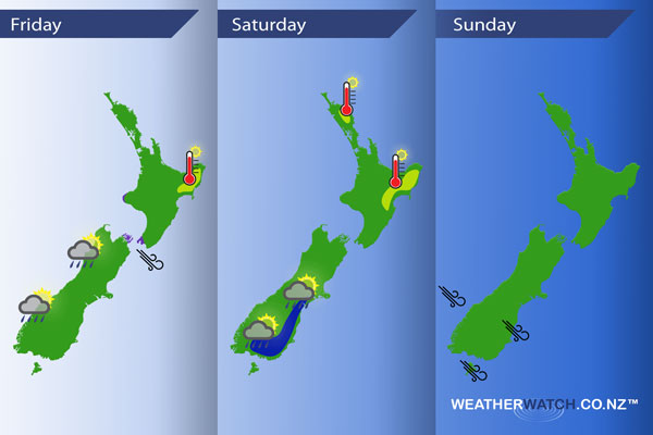
A front pushes northwards over New Zealand today, winds preceding the front from the northwest then changing southwest in behind. A westerly airflow covers the country on Saturday although a low forms out to the east influencing a southwest change about the east coast of the South Island. A southwest airflow continues on Sunday for most however northwesterlies strengthen about the far south.
Friday
Purple – Blustery northwest winds develop ahead of a front today especially through Cook Strait where winds may gust to gale force. Winds about the inner South Island while gusty are not looking to bad, winds ease in the evening.
Some rain (possibly heavy) along the West Coast this morning eases midday onwards.
Yellow – Afternoon high’s may reach into the mid 20’s for parts of Hawkes Bay and Gisborne.
Saturday
Blue – Showers about Southland through to South Canterbury in the east may be heavy late afternoon / evening in isolated spots, low risk of a thunderstorm. This shower activity is influenced by a southwest change.
Yellow – Temperatures in the low to mid 20’s for the areas marked below during the afternoon.
Sunday
A northwesterly airflow strengthens about the lower South Island during the day, winds may gust to gale at times from afternoon.
– Please note, the idea behind this update is to focus on the main weather highlights, which is why not all regions are mentioned.
For specific 10 day information for your city, town, rural community or island please see the 1500 forecasts on our homepage!
– Aaron Wilkinson, WeatherWatch.co.nz
Comments
Latest Video

Wednesday Newsfeed: New southern cold front as sub-tropical low tracks near north
A southern cold front moves into the South Island today & tonight while low pressure in the sub-tropics deepens north…
Related Articles

Thursday Newsfeed: Colder air heads north
A colder southerly flow is spreading up and across NZ today bringing frosty weather to inland parts of both main…

VIDEO: !Frost Alert as high pressure brings colder air, a change possible next week
Massive high pressure near Tasmania is bringing in a colder southerly for NZ today and that means frosts over the…
Wednesday Newsfeed: New southern cold front as sub-tropical low tracks near north
A southern cold front moves into the South Island today & tonight while low pressure in the sub-tropics deepens north…


Add new comment