InfoGraphic: The Main Weather News Highlights across NZ: Fri, Sat, Sun
8/06/2017 7:00pm

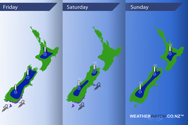
A ridge lies over much of the country today however it does weaken from afternoon for the South Island as a northwesterly airflow develops. A front moves onto the lower South Island later this evening. A front pushes northwards on Saturday bringing cold temperatures but not much in the way of rough weather, cool west to southwesterly winds continue on Sunday.
Friday
Blue – A frosty start this morning, lows ranging between -4 and +2’s celsius in the shaded areas below. Although we have -6 degrees in one spot, Twizel does it again.
Purple – Later in the evening then overnight a southwest change hits the lower South Island then pushes northwards bringing with it brisk to strong winds about coastal areas.
Saturday
Blue – A tad cold to start for some however there may be no frosts, windy conditions keep most regions above zero.
Purple – Brisk south to southwesterly winds about the eastern South Island ease from afternoon, further north breezy southerlies develop about Wellington late morning then push into the eastern North Island from afternoon in the form of southwesterlies although not looking as strong now as yesterdays graphic.
Sunday
Blue – A cold start inland, -3 to +2 for the shaded areas below. The coldest temperatures being about inland South Island areas.
– Please note, the idea behind this update is to focus on the main weather highlights, which is why not all regions are mentioned.
For specific 10 day information for your city, town, rural community or island please see the 1500 forecasts on our homepage!
– Aaron Wilkinson, WeatherWatch.co.nz
Comments
Latest Video

Weekend Newsfeed: Winter weather in the south, high pressure in the north
A cold change is affecting the lower half of the South Island Saturday bringing snow to the hills and ranges…
Related Articles
Weekend Newsfeed: Winter weather in the south, high pressure in the north
A cold change is affecting the lower half of the South Island Saturday bringing snow to the hills and ranges…

VIDEO: 7 Day NZ RainWatch: Who gets rain, who misses out
A cold front will bring winter-like weather into the lower South Island on Saturday but won’t make to the top…

MetService Auckland rain radar offline – helicopter called in
Aucklanders may have noticed the rain radar isn’t working this week. MetService has provided us with an update ahead of…


Add new comment