
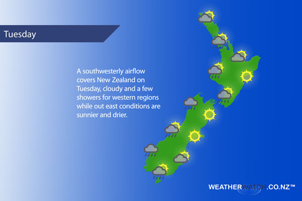
A southwesterly airflow lies over New Zealand on Tuesday.
Cloudy areas and occasional sun for the upper North Island, chance of a shower or two. Sunny areas more frequent about the Bay Of Plenty, conditions likely to be drier also however still can’t rule out a shower or two. West to southwesterly winds.
Cloudy periods about the lower Western North Island with a shower or two possible, many dry areas also. Breezy westerly winds. Sunny along the East Coast, westerly winds may tend a little more southwest for a time in the afternoon. Perhaps even swinging around to the ENE for some coastal fringe parts of Hawkes Bay and Gisborne after midday.
Sunny about Wellington with northerly winds.
Sunny for the top of the South Island with afternoon east to northeast winds about Marlborough, southwesterlies for Nelson. Sunny skies in Canterbury, afternoon east to northeasterly winds, becoming breezy about the coast.
Morning showers along the West Coast then long dry periods from afternoon, still the risk of a shower or two at times. Southwesterly winds. A few morning showers clear for Southland then afternoon sunny spells break through, brisk westerly winds. Otago sees mostly sunny weather generally although there may be some cloud about coastal Otago in the morning, winds from the west or northwest.
Blue – Heavy form of precipitation – or – low temperatures, typically below 1 to 2 degrees celsius.
White – Snow
Purple – Strong winds.
Yellow – Temperatures around the mid 20 degree mark or over.
Not all regions and towns have been mentioned above. For specific 10 day information for your city, town, rural community or island please see the 1500 forecasts on our homepage!
– Aaron Wilkinson, WeatherWatch.co.nz
Comments
Latest Video

Sunday Newsfeed: Low pressure areas increase offshore near northern NZ in days ahead
A light easterly kicks in to the north of the North Island on Sunday as high pressure moves south east…
Related Articles
Sunday Newsfeed: Low pressure areas increase offshore near northern NZ in days ahead
A light easterly kicks in to the north of the North Island on Sunday as high pressure moves south east…

VIDEO: 7 Day NZ RainWatch: Who gets rain, who misses out
A cold front will bring winter-like weather into the lower South Island on Saturday but won’t make to the top…

MetService Auckland rain radar offline – helicopter called in
Aucklanders may have noticed the rain radar isn’t working this week. MetService has provided us with an update ahead of…


Add new comment