
A gusty west to northwesterly airflow lies over most of New Zealand on Tuesday meanwhile a front pushes northwards over the South Island during the day bringing in a cooler south to southwesterly change.
Sunny spells for Northland and the Bay Of Plenty, cloudy areas elsewhere with the chance of a shower for the upper North Island. Winds from the west. Mainly sunny in the east, brisk to strong northwesterly winds through Cook Strait.
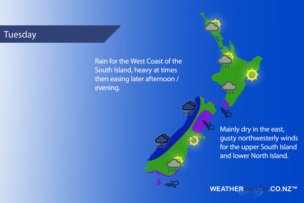
Rain for the West Coast of the South Island with heavy falls at times, easing late afternoon / evening. Mainly dry in the east with some high cloud developing, gusty northwesterlies. A southerly change pushes into South Canterbury early afternoon reaching North Canterbury late afternoon bringing some increasing cloud, overnight drizzle possible.
A few showers about Southland push into Otago late morning as westerlies tend more southwest, many parts of Otago especially inland may remain fairly dry with sunny spells.
Not all regions and towns have been mentioned above. For specific 10 day information for your city, town, rural community or island please see the 1500 forecasts on our homepage!
– Aaron Wilkinson, WeatherWatch.co.nz
Comments
Latest Video

VIDEO: Anzac Day + weather to next Tuesday
Anzac Day looks mild for many parts of NZ with windy nor’westers gusting to gale force for some. Many regions…
Related Articles

Weekend Newsfeed: High pressure arrives, dragging in some cloud, more settled nationwide
Sunday – High pressure crosses NZ properly and winds ease for many regions and most (but not all) showers will…

Anzac Day Newsfeed: Severe gales, heavy rain for some, settled for others
Updated 4am — High pressure over northern NZ moves east of the country on Thursday while a storm south of…
VIDEO: Anzac Day + weather to next Tuesday
Anzac Day looks mild for many parts of NZ with windy nor’westers gusting to gale force for some. Many regions…


Add new comment