
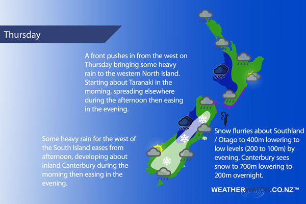
A front pushes in from the west, gradually moving over the North Island on Thursday afternoon / evening meanwhile cold southerlies for the South Island gradually move northwards.
Blue – Heavy form of precipitation or cold temperatures, typically below 1 to 2 degrees celsius.
White – Snow
Purple – Strong winds.
Yellow – Temperatures around the mid 20 degree mark or over.
Not all regions and towns have been mentioned above. For specific 10 day information for your city, town, rural community or island please see the 1500 forecasts on our homepage!
– Aaron Wilkinson, WeatherWatch.co.nz
Comments
Latest Video

ClimateWatch: MAY’s outlook as El Niño ends, NEUTRAL pattern arrives (+Video & 13 Maps)
El Niño may be technically gone but the weather pattern it created is still with our part of the world. By…
Related Articles
ClimateWatch: MAY’s outlook as El Niño ends, NEUTRAL pattern arrives (+Video & 13 Maps)
El Niño may be technically gone but the weather pattern it created is still with our part of the world. By…

Weekend Newsfeed: High pressure starts to grow around NZ, easterlies in the north
The cooler SW flow of this past week is going to fade more going into the weekend as high pressure…

VIDEO: NZ RainWatch -Not much coming next 7 days
High pressure is the main feature driving NZ’s weather for the next 10 days but low pressure is trying to…


Add new comment